Texas State Highway 78
| ||||
|---|---|---|---|---|
 | ||||
| Route information | ||||
| Maintained by TxDOT | ||||
| Length: | 90.83 mi[1] (146.18 km) | |||
| Existed: | 1926 – present | |||
| Major junctions | ||||
| South end: |
 I-30 in Dallas I-30 in Dallas | |||
|
 US 82 in Bonham US 82 in Bonham | ||||
| North end: |
 OK 78 at Texas–Oklahoma state line OK 78 at Texas–Oklahoma state line | |||
| Highway system | ||||
| ||||


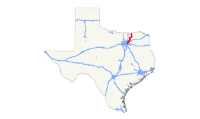
State Highway 78 or SH 78 is a state highway that follows surface roads in a predominantly southwest-to-northeast direction in the Dallas area before traveling 90 miles (145 km) north-northeast to the Oklahoma State border.
Route description
The highway's southern terminus is at Interstate 30 in Dallas. From there, it follows Grand Avenue along White Rock Lake and then Garland Road into Garland as it passes Interstate 635. In downtown Garland, Highway 78 follows the central streets of Avenues B and D before joining Lavon Drive and moving northeastward.
It continues to the northeast through Sachse and Wylie, crossing between Lake Ray Hubbard and Lake Lavon. It passes through Lavon before turning north through Farmersville and Blue Ridge. At SH 160, just before SH 121, SH 78 turns east, continuing to Leonard before turning northeast again to Bailey. At Bailey, SH 78 turns north and cuts through Bonham (as Center Street) just before it reaches the border with Oklahoma, where it crosses a 1938 truss bridge over the Red River. The route continues as Oklahoma State Highway 78 through Durant to its terminus at Tishomingo.
History
The highway was originally designated in 1926 along its current route. Part of this route was used to be designated as SH 5C.
SH 78A was a spur designated by 1928 from Desert to Denison. This spur was renumbered as SH 160 by 1931.
The section of the highway between I-30 and SH 66 was part of U.S. 67 until sometime in the 1960s.
Flooding
In 1990 SH 78 was flooded, as engineers at the Lake Lavon Dam decided to release the water from the lake into the East Fork of the Trinity River. For a month and a half, the traffic going between Wylie and the Eastern portion of Collin County was diverted to go through the city of Rockwall, a nearly 20-mile (32 km) detour. The railroad that ran adjacent to the highway was completely washed out, and significant shoulder damage was done to the highway.
Junction List
| County | Location | mi | km | Destinations | Notes |
|---|---|---|---|---|---|
| Dallas | Dallas | I-30 (R.L. Thornton Freeway) | Southern terminus; I-30 exits 48B-49A | ||
 Loop 12 (Buckner Boulevard) Loop 12 (Buckner Boulevard) | |||||
  Spur 244 west (Northwest Highway) to I-635 Spur 244 west (Northwest Highway) to I-635 | |||||
| Garland | I-635 west (Lyndon B. Johnson Freeway) | I-635 exit 8 | |||
 SH 66 east SH 66 east | |||||
 Pres. George Bush Tpk. Pres. George Bush Tpk. | Interchange | ||||
| Collin | Wylie |  FM 544 west FM 544 west | |||
 FM 2514 north (Ballard Avenue) FM 2514 north (Ballard Avenue) | |||||
 FM 3412 west (Brown Street) FM 3412 west (Brown Street) | |||||
| Lavon |  SH 205 south – Rockwall SH 205 south – Rockwall | ||||
  Bus. SH 78 north – Lavon Bus. SH 78 north – Lavon | |||||
| Bus. SH 78 south – Lavon | |||||
| |  FM 6 east – Caddo Mills FM 6 east – Caddo Mills | ||||
| | Bus. SH 78 north – Copeville | ||||
| | Bus. SH 78 south – Copeville | ||||
| Farmersville |  US 380 – McKinney, Greenville US 380 – McKinney, Greenville | Interchange | |||
| Bus. SH 78 north | |||||
| | Bus. SH 78 south – Farmersville | ||||
| |  FM 2756 west FM 2756 west | ||||
| | Bus. SH 78 north – Blue Ridge | ||||
| Blue Ridge |  FM 981 – Blue Ridge, Celeste FM 981 – Blue Ridge, Celeste | ||||
| | Bus. SH 78 south – Blue Ridge | ||||
| |   SH 160 north to SH 121 – Whitewright SH 160 north to SH 121 – Whitewright | ||||
| Fannin | |  FM 815 north – Trenton FM 815 north – Trenton | |||
| | FM 981 north | South end of FM 981 overlap | |||
| | FM 981 south | North end of FM 981 overlap | |||
| Leonard |  FM 896 north FM 896 north | ||||
 US 69 south – Celeste US 69 south – Celeste | South end of US 69 overlap | ||||
 US 69 north / Spur 241 west – Whitewright US 69 north / Spur 241 west – Whitewright | North end of US 69 overlap | ||||
| |  FM 1553 north FM 1553 north | ||||
| Bailey |  FM 816 south FM 816 south | ||||
 SH 11 – Whitewright, Wolfe City SH 11 – Whitewright, Wolfe City | |||||
| |  FM 1552 east FM 1552 east | ||||
| | FM 1553 west | ||||
| |  FM 68 east FM 68 east | ||||
| |  FM 1629 south FM 1629 south | ||||
| |  FM 271 south – Bonham State Park FM 271 south – Bonham State Park | ||||
| Bonham |  SH 56 – Ector, Dodd City SH 56 – Ector, Dodd City | ||||
 Loop 205 (10th Street) Loop 205 (10th Street) | |||||
| US 82 – Sherman, Paris | |||||
 FM 898 north FM 898 north | |||||
| | SH 121 south – Melissa, McKinney | ||||
| |  FM 1753 west FM 1753 west | ||||
| |  FM 1396 east FM 1396 east | ||||
| |  FM 274 west FM 274 west | ||||
| Red River | State Highway 78 Bridge — Highway continues into Oklahoma as SH-78 | ||||
1.000 mi = 1.609 km; 1.000 km = 0.621 mi
| |||||