Tok Airport
| Tok Airport | |||||||||||
|---|---|---|---|---|---|---|---|---|---|---|---|
 | |||||||||||
|
IATA: | |||||||||||
| Summary | |||||||||||
| Airport type | Public | ||||||||||
| Owner | Alaska DOT&PF - Northern Region | ||||||||||
| Serves | Tok, Alaska | ||||||||||
| Elevation AMSL | 1,670 ft / 509 m | ||||||||||
| Coordinates | 63°18′12″N 143°00′04″W / 63.30333°N 143.00111°W | ||||||||||
| Runways | |||||||||||
| |||||||||||
| Statistics (2005) | |||||||||||
| |||||||||||
Tok Airport (IATA: TKJ, ICAO: PATJ, FAA LID: TKJ) was a state-owned public-use airport located two nautical miles (4 km) south of the central business district of Tok,[1] in the Southeast Fairbanks Census Area of the U.S. state of Alaska.
Facilities and aircraft
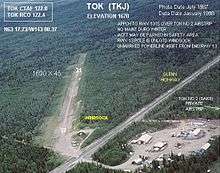
Tok Airport has one runway designated 13/31 with a 1,690 by 45 ft (515 x 14 m) gravel and turf surface.[2] For the 12-month period ending December 31, 2005, the airport had 600 aircraft operations, an average of 50 per month: 83% general aviation and 17% air taxi. At that time there were 17 aircraft based at this airport, all single-engine.[1]
Other airports in Tok
- Tok Junction Airport (IATA: TKJ, ICAO: PFTO, FAA LID: 6K8) is state-owned public-use located at 63°19′46″N 142°57′13″W / 63.32944°N 142.95361°W, one nautical mile (2 km) east of the central business district of Tok. It has one runway designated 7/25 with a 2,509 x 50 ft (765 x 15 m) asphalt surface.[3]
- Tok 2 Airport (FAA LID: 8AK9) is a private-use airport located at 63°18′32″N 143°01′04″W / 63.30889°N 143.01778°W, on the opposite side of Glenn Highway from the Tok Airport. It has one runway designated 10/28 with a 2,035 x 80 ft (620 x 24 m) gravel surface.[4]
References
- 1 2 3 "Tok Airport (PATJ / TKJ) - FAA information effective 30 August 2007". FAA data republished by AirNav. Archived from the original on 14 September 2007.
- ↑ "Annotated aerial photo of Tok (TKJ)". Federal Aviation Administration, Alaska Region. Summer 1975. Archived from the original (JPG) on 14 January 2009.
- ↑ FAA Airport Master Record for 6K8 (Form 5010 PDF). Federal Aviation Administration. Effective 25 August 2011.
- ↑ FAA Airport Master Record for 8AK9 (Form 5010 PDF). Federal Aviation Administration. Effective 25 August 2011.


External links
- Aerial photo of Tok (TKJ) and Tok 2 (8AK9) (JPG). Federal Aviation Administration, Alaska Region. Summer 1975.
- Airport diagram of Tok (TKJ) and Tok 2 (8AK9) (GIF). Federal Aviation Administration, Alaska Region. September 2004.
- Topographic map showing Tok and landing strip to the south. USGS The National Map via MSR Maps. July 1948.
- Accident history for TKJ at Aviation Safety Network


This article is issued from Wikipedia - version of the 9/12/2016. The text is available under the Creative Commons Attribution/Share Alike but additional terms may apply for the media files.