Trou aux Cerfs
| Trou aux Cerfs | |
|---|---|
|
Crater of Trou aux Cerfs | |
| Highest point | |
| Elevation | 605 m (1,985 ft) |
| Coordinates | 20°18′54″S 57°30′18″E / 20.31500°S 57.50500°ECoordinates: 20°18′54″S 57°30′18″E / 20.31500°S 57.50500°E |
| Geography | |
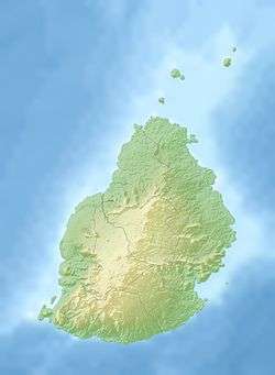  Trou aux Cerfs Location in Mauritius | |
| Location | Curepipe, Mauritius |
| Geology | |
| Mountain type | Dormant - Volcanic crater |
| Climbing | |
| Easiest route | Car/Walking |
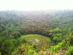
Trou aux Cerfs (also known as Murr's Volcano) is a dormant volcano with a well-defined cone and crater. It is 605 m (1,985 ft) high and located in Curepipe, Mauritius. The crater has been alternately described as 300[1] and 350 meters in diameter,[2] and is 80 meters deep.[2]
According to experts, the volcano is lying dormant but could become active at any time within the next thousand years.
The crater is only accessible down a steep embankment which is considered dangerous. Water and silt have clogged the crater, making it even less accessible.
References
 |
Wikimedia Commons has media related to Trou aux Cerfs. |
- ↑ "Trou aux Cerfs". Mauritius UK Connection. Retrieved 2007-03-17.
- 1 2 "Trou aux Cerfs volcano". Government of Mauritius. Retrieved 2007-03-17.
This article is issued from Wikipedia - version of the 9/7/2016. The text is available under the Creative Commons Attribution/Share Alike but additional terms may apply for the media files.