Turtle River (Wisconsin)
| Turtle River | |
|---|---|
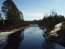 Turtle River near the Highway 51 bridge. | |
| Basin | |
| Main source | 46°13′41″N 89°53′49″W / 46.2280045°N 89.8968275°W |
| River mouth |
1,572 feet (479 m) 46°07′20″N 90°11′27″W / 46.1221705°N 90.1907234°WCoordinates: 46°07′20″N 90°11′27″W / 46.1221705°N 90.1907234°W |
| Features | |
| Tributaries |
|
The Turtle River is a river in Vilas County and Iron County in the state of Wisconsin in the United States. Its source is South Turtle Lake near Winchester. It flows into the Turtle-Flambeau Flowage.
Historically the Turtle River was an important part of an extensive network of canoe routes linked by short land portages, used by the Ojibwe and fur traders.[1] In modern times the river and the lakes it connects are popular recreational waterways.
References
- ↑ Wurl, Jon G. (2013). "The 1847 geological survey trip of J. G. Norwood, MD". Tomahawk Area Historical Society. Retrieved March 19, 2015.
External links
U.S. Geological Survey Geographic Names Information System: Turtle River (Wisconsin)
This article is issued from Wikipedia - version of the 9/11/2016. The text is available under the Creative Commons Attribution/Share Alike but additional terms may apply for the media files.