U.S. Route 5 in Massachusetts
| ||||
|---|---|---|---|---|
|
Map of central Massachusetts with US 5 highlighted in red | ||||
| Route information | ||||
| Maintained by MassDOT | ||||
| Length: | 53.46 mi[1] (86.04 km) | |||
| Major junctions | ||||
| South end: |
 US 5 in Enfield, CT US 5 in Enfield, CT | |||
| ||||
| North end: |
US 5 in Guilford, VT | |||
| Location | ||||
| Counties: | Hampden, Hampshire, Franklin | |||
| Highway system | ||||
| ||||
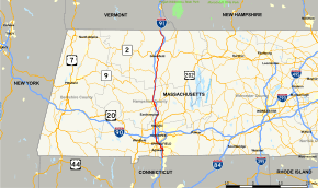


U.S. Route 5 (US 5) is a north–south U.S. Highway extending from southern Connecticut to the northernmost part of Vermont. In Massachusetts, the route travels 53.5 miles (86.1 km), paralleling the Connecticut River and Interstate 91 (I-91) through Hampden, Hampshire, and Franklin counties.
Route description
US 5 stays very close to the Connecticut River and Interstate 91. It enters the state at the town of Longmeadow on the east bank of the river going up to Springfield. In Springfield, US 5 then overlaps with Interstate 91 (I-91) for about 0.5 miles (0.80 km), then separates as its own freeway crossing the Connecticut River on the South End Bridge into Agawam. The freeway portion travels for about 3.3 miles (5.3 km) up to West Springfield. From the town of Northampton up to Bernardston, US 5 travels concurrent with Massachusetts Route 10 (Route 10 for 26 miles (42 km). US 5 also passes through Holyoke, Hatfield, Whately, Deerfield, and Greenfield. As in Connecticut, and Vermont US 5 has many interchanges with the parallel I-91.
Major intersections
| County | Location | mi[1] | km | Destinations | Notes |
|---|---|---|---|---|---|
| Hampden | Longmeadow | 0.00 | 0.00 | US 5 south – Enfield, Hartford | Continuation into Connecticut |
| 1.80 | 2.90 |  Route 192 south – East Longmeadow, Stafford Springs, CT Route 192 south – East Longmeadow, Stafford Springs, CT | Northern terminus of Route 192 | ||
| Springfield | 3.50 | 5.63 |  I‑91 south – Hartford, CT I‑91 south – Hartford, CT | Southern terminus of concurrency with I-91; Exit 1 on I-91 | |
| 3.70 | 5.95 |  Route 83 south – Forest Park, East Longmeadow Route 83 south – Forest Park, East Longmeadow | Northern terminus of Route 83; Exit 2 on I-91 | ||
| 3.90 | 6.28 | I‑91 north – Holyoke | Northern terminus of concurrency with I-91; Exit 3 on I-91 | ||
| Connecticut River | South End Bridge | ||||
| Agawam | 4.60 | 7.40 |  Route 57 west – Agawam, Southwick Route 57 west – Agawam, Southwick | Rotary interchange; Eastern terminus of Route 57 | |
| West Springfield | 5.80 | 9.33 |  Route 147 west – West Springfield, Agawam Route 147 west – West Springfield, Agawam | Rotary interchange; Eastern terminus of Route 147, to Memorial Bridge | |
| 7.00 | 11.27 |  US 20 – Westfield, Springfield US 20 – Westfield, Springfield | Rotary interchange | ||
| 9.30 | 14.97 |  I‑91 to I‑391 – Holyoke, Springfield I‑91 to I‑391 – Holyoke, Springfield | Exit 13 on I-91 | ||
| 10.80 | 17.38 |  I‑91 / I‑90 – Holyoke, Springfield, Albany, Boston I‑91 / I‑90 – Holyoke, Springfield, Albany, Boston | Exit 4 on I-90; Exit 14 on I-91 | ||
| Holyoke | 13.80 | 22.21 |  US 202 to I‑91 – Westfield, Southwick, South Hadley US 202 to I‑91 – Westfield, Southwick, South Hadley | ||
| 14.60 | 23.50 |  Route 141 east – Holyoke Center, Chicopee Falls Route 141 east – Holyoke Center, Chicopee Falls | One-way eastbound | ||
| 14.80 | 23.82 | Route 141 west to I‑91 – Easthampton | One-way westbound | ||
| 15.00 | 24.14 | To US 202 – South Hadley Falls, Athol | Via Lincoln Street | ||
| Hampshire | Northampton | 21.90 | 35.24 | I‑91 – Deerfield, Greenfield, Holyoke | Exit 18 on I-91 |
| 22.90 | 36.85 |   Route 9 / Route 10 south – Easthampton, Pittsfield, Amherst, Worcester Route 9 / Route 10 south – Easthampton, Pittsfield, Amherst, Worcester | Southern terminus of concurrency with Route 10 | ||
| 24.30 | 39.11 | I‑91 north – Greenfield | Northbound exit and southbound entrance; Exit 20 on I-91 | ||
| 26.10 | 42.00 | I‑91 south – Holyoke, Springfield | Northbound access via Elm Street; Exit 21 on I-91 | ||
| Hatfield | 28.65 | 46.11 | I‑91 south – Holyoke, Springfield | Exit 22 on I-91 | |
| Franklin | Whately | 30.50– 31.20 | 49.08– 50.21 | I‑91 north – Greenfield, Brattleboro, VT | Exit 23 on I-91 |
| 33.70 | 54.23 | I‑91 south – Holyoke, Springfield | No access to I-91 north; Exit 24 on I-91 | ||
| 33.90 | 54.56 |  Route 116 south – Sunderland, Amherst Route 116 south – Sunderland, Amherst | Southern terminus of concurrency with Route 116 | ||
| Deerfield | 34.80 | 56.01 | Route 116 north to I‑91 – Conway, Ashfield | Northern terminus of concurrency with Route 116 | |
| Deerfield River | Bridge | ||||
| Greenfield | 42.50 | 68.40 |  Route 2A – Athol, Shelburne Route 2A – Athol, Shelburne | Court Square, site of historic road marker | |
| 44.20 | 71.13 |  Route 2 to I‑91 – Boston, North Adams Route 2 to I‑91 – Boston, North Adams | Diamond interchange | ||
| Bernardston | 49.00 | 78.86 | Route 10 north to I‑91 – Northfield | Northern terminus of concurrency with Route 10 | |
| 53.46 | 86.04 | US 5 north – Brattleboro, White River Junction | Continuation into Vermont | ||
1.000 mi = 1.609 km; 1.000 km = 0.621 mi
| |||||
See also
-
 Massachusetts portal
 -
 U.S. Roads portal
References
- 1 2 Google (2014-01-22). "U.S. Route 7 in Massachusetts" (Map). Google Maps. Google. Retrieved 2014-01-22.
External links
 |
Wikimedia Commons has media related to U.S. Route 5 in Massachusetts. |
| U.S. Route 5 | ||
|---|---|---|
| Previous state: Connecticut |
Massachusetts | Next state: Vermont |