U.S. Route 501 in North Carolina
| ||||
|---|---|---|---|---|
|
Route of US 501 in North Carolina highlighted in red | ||||
| Route information | ||||
| Maintained by NCDOT | ||||
| Length: | 170 mi[1] (274 km) | |||
| Existed: | 1927 – present | |||
| Major junctions | ||||
| South end: |
  US 301 / US 501 at the South Carolina line near Dillon, SC US 301 / US 501 at the South Carolina line near Dillon, SC | |||
  I‑74 / US 74 in Laurinburg I‑74 / US 74 in Laurinburg US 421 in Sanford US 421 in Sanford  I‑40 in Durham I‑40 in Durham NC 147 in Durham NC 147 in Durham  I‑85 / US 70 in Durham I‑85 / US 70 in Durham | ||||
| North end: |
US 501 at the Virginia line near South Boston, VA | |||
| Location | ||||
| Counties: | Robeson, Scotland, Hoke, Moore, Lee, Chatham, Orange, Durham, Person | |||
| Highway system | ||||
| ||||
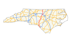

U.S. Route 501 (US 501) is a north–south United States highway that traverses the majority of North Carolina in concurrency with US 15, known as "15-501" ("Fifteen Five-o-one").
Route description
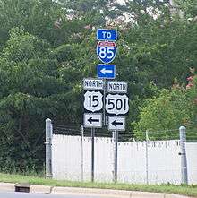
US 501 enters North Carolina at the South Carolina state line with an intersection of Interstate 95 (I-95) while overlapping US 301, nearby South of the Border. It goes northwest through Rowland where the overlap with US 301 terminates, and then travels through Raemon to Laurinburg. Once at Laurinburg, it overlaps briefly with I-74/US 74 before connecting with US 15. The majority of the route, to this point, is a two-lane rural road.[1]
Merging with US 15, it becomes what is known as "15-501" ("Fifteen Five-o-one"), a concurrency that extends for 106 miles (171 km) across central North Carolina. After Laurinburg it goes north to Aberdeen, linking briefly with US 1 before continuing to Pinehurst. In Pinehurst, 15-501 goes through a roundabout then continues north through Carthage, then back to US 1. After traveling through Sanford on another brief concurrency with US 1, it exits off the freeway and goes due north to Pittsboro. After Pittsboro, 15-501 becomes an expressway connecting the cities of Chapel Hill and Durham; this section of the route is famous because of the two universities it connects: University of North Carolina at Chapel Hill and Duke University. Though the road is a symbol of the separation of the Carolina–Duke rivalry, NCDOT has been trying to remedy that by making the route a superstreet for better traffic flow.[2] In Durham, 15-501 upgrades to an urban freeway, allowing for quick access from south Durham to north; the freeway ends merging into I-85. At exit 176B on I-85, US 501 splits off towards Roxboro, while US 15 continues with I-85 towards Oxford.[1]
After Durham, US 501 goes north to Roxboro, then onto South Boston, Virginia after crossing the state line, the majority of which is a four-lane expressway.[1]
History
When US 501 was established in 1927, it was aligned along North Carolina Highway 13 (NC 13) from Durham north through Roxboro to the Virginia state line.
In 1934, it was overlapped with US 15 from Durham south to Laurinburg. From there, it went southeast to Rowland and then to the South Carolina border. This extension south replaced NC 22, NC 71, and NC 241.
In 1953, US 501 was bypassed around Chapel Hill. In 1956 or 1957, US 501 was bypassed west of Sanford. Between 1960-1962, US 501 was bypassed around Laurinburg.[3]
North Carolina Highway 13 (1921-1930)
| |
|---|---|
| Location: | Durham–Virginia State Line |
| Length: | 43 mi[4] (69 km) |
| Existed: | 1921–1930 |

North Carolina Highway 13 was an original state highway running from Durham, north through Rougemont and Roxboro ending at SR 18 at the Virginia State Line. The highway's routing appeared on the 1916 Highway Map by the North Carolina State Highway Commission for the five year federal aid program.[5] However NC 13 was not officially marked on any state highway maps until 1924; where it was routed from NC 10/NC 75 in Durham north through Rougemont and Timberlake to NC 57 east of Roxboro. NC 13 turned toward the west into Roxboro, before intersecting NC 144 and turning north.[6] The highway had its northern terminus at the Virginia State Line near South Boston. By 1926 the routing of NC 13 was shifted slightly to the west between Timberlake and Roxboro, providing a direct link between the cities.[7] The route was deleted in 1930, with US 501/NC 55 taking over the entirety of the routing.[4][8]
Junction list
| County | Location | mi[1] | km | Exit | Destinations | Notes | |
|---|---|---|---|---|---|---|---|
| Robeson | | 0.0 | 0.0 | US 301 south / US 501 south – South of the Border I‑95 – Lumberton, Fayetteville, Florence I‑95 – Lumberton, Fayetteville, Florence | South Carolina state line | ||
| Rowland | 2.7 | 4.3 |  US 301 north / NC 130 east – Lumberton, Fairmont US 301 north / NC 130 east – Lumberton, Fairmont | North end of US 301 and east end of NC 130 overlap | |||
| | 4.0 | 6.4 |  NC 710 west – Pembroke NC 710 west – Pembroke | ||||
| Raemon | 10.2 | 16.4 | NC 130 west – Maxton | West end of NC 130 overlap | |||
| | 14.0 | 22.5 |  NC 83 – Maxton, Clio NC 83 – Maxton, Clio | ||||
| Scotland | Laurinburg | 21.0 | 33.8 |   US 501 Bus. north (Johns Road) US 501 Bus. north (Johns Road) | |||
| 21.7 | 34.9 | I‑74 east / US 74 east – Lumberton, Wilmington | East end of I-74/US 74 overlap | ||||
| US 501 overlaps with Interstate 74 (exits 185 to 183). | |||||||
| Laurinburg | 23.2 | 37.3 |   I‑74 west / US 15 south / US 74 west / US 401 south – Hamlet, Rockingham, McColl I‑74 west / US 15 south / US 74 west / US 401 south – Hamlet, Rockingham, McColl | South end of US 15/US 401 overlap | |||
| 24.2 | 38.9 | US 74 Bus. (Church Street) – Hamlet | |||||
| 26.1 | 42.0 |  US 401 north / US 15 Bus. south / US 501 Bus. south – Fayetteville US 401 north / US 15 Bus. south / US 501 Bus. south – Fayetteville | North end of US 401 overlap | ||||
| | 29.3 | 47.2 |  NC 144 (Old Wire Road) – Wagram NC 144 (Old Wire Road) – Wagram | ||||
| Moore | Aberdeen | 49.1 | 79.0 |  NC 211 east – Raeford NC 211 east – Raeford | East end of NC 211 overlap | ||
| 49.5 | 79.7 |  US 1 south – Rockingham US 1 south – Rockingham | South end of US 1 overlap | ||||
| 49.7 | 80.0 |  NC 5 – Pinehurst NC 5 – Pinehurst | |||||
| 51.4 | 82.7 | US 1 north – Southern Pines | North end of US 1 overlap | ||||
| Pinehurst | 55.2 | 88.8 |  NC 2 / NC 211 west – Southern Pines, West End NC 2 / NC 211 west – Southern Pines, West End | Roundabout, west end of NC 211 overlap | |||
| | 59.0 | 95.0 |  NC 73 west – West End NC 73 west – West End | ||||
| Carthage | 62.5 | 100.6 |  NC 22 south – Southern Pines NC 22 south – Southern Pines | South end of NC 22 overlap | |||
| 63.6 | 102.4 | NC 22 north (McNiell Street) | North end of NC 22 overlap | ||||
| 65.7 | 105.7 |   NC 24 east / NC 27 east (Monroe Street) NC 24 east / NC 27 east (Monroe Street) | East end of NC 24/NC 27 overlap | ||||
| | 67.5 | 108.6 | NC 24 east / NC 27 east – Cameron | West end of NC 24/NC 27 overlap | |||
| Lee | | 76.0 | 122.3 | US 1 south – Cameron, Southern Pines | South end of US 1 overlap | ||
| Tramway | 78.6 | 126.5 |  NC 78 east (Tramway Road) – Cameron NC 78 east (Tramway Road) – Cameron | ||||
| Sanford | 81.0 | 130.4 |  US 1 Bus. north / NC 42 – Asheboro, Fuquay-Varina US 1 Bus. north / NC 42 – Asheboro, Fuquay-Varina | ||||
| 82.3 | 132.4 | Spring Lane | |||||
| 82.8 | 133.3 | 69A |  US 421 / NC 87 south – Dunn, Greensboro US 421 / NC 87 south – Dunn, Greensboro | South end of NC 87 overlap | |||
| 83.5 | 134.4 | 69B | Burns Drive | ||||
| 84.0 | 135.2 | 70 | Oscar Keller Jr Highway – Fuquay-Varina | Future US 421 | |||
| 85.0 | 136.8 | 71 | US 1 north / US 1 Bus. south – Apex, Raleigh | North end of US 1 overlap | |||
| Chatham | Pittsboro | 98.2 | 158.0 | NC 87 north – Graham, Burlington | North end of NC 87 overlap | ||
| 99.2 | 159.6 |  US 64 Bus. US 64 Bus. | |||||
| 101.8 | 163.8 | US 64 – Siler City, Apex | |||||
| Orange | Chapel Hill | 115.0 | 185.1 |  NC 54 west – Graham NC 54 west – Graham | South end of NC 54 overlap | ||
| 117.2 | 188.6 | NC 54 east (Raleigh Road) | North end of NC 54 overlap | ||||
| 119.2 | 191.8 | Franklin Street | |||||
| Durham | Durham | 121.0 | 194.7 | I‑40 – Greensboro, Raleigh | |||
| 123.0 | 197.9 | 105 | US 15 Bus. north / US 501 Bus. north (Durham-Chapel Hill Boulevard) | ||||
| 124.5 | 200.4 | 106 | Cornwallis Road | ||||
| 125.5 | 202.0 | 107 |  NC 751 (Cameron Boulevard) NC 751 (Cameron Boulevard) | ||||
| 126.2 | 203.1 | 108 | US 70 Bus. (Hillsborough Road) / NC 147 (Durham Freeway) | Signed as exits 108A (NC 147 south), 108B (NC 147 north), 108C (Hillsbrough Road) | |||
| 127.4 | 205.0 | 109 | I‑85 south – Greensboro | South end of I-85 overlap; southbound exit and northbound entrance | |||
| US 501 overlaps with Interstate 85 (exits 174A to 176B). | |||||||
| 130.0 | 209.2 | I‑85 north / US 15 north / US 70 east – Henderson, Petersburg | North end of I-85/US 15 and east end of US 70 overlap | ||||
| 132.5 | 213.2 | US 501 Bus. (Roxboro Street) | |||||
| Person | | 146.0 | 235.0 |  NC 57 south – Hillsborough NC 57 south – Hillsborough | South end of NC 57 overlap | ||
| Roxboro | 156.5 | 251.9 |  US 158 east – Oxford US 158 east – Oxford | East end of US 158 overlap | |||
| 157.0 | 252.7 |  NC 157 south – Durham NC 157 south – Durham | |||||
| 158.0 | 254.3 |  US 158 west / NC 49 south / NC 57 north – Yanceyville, Milton, Haw River US 158 west / NC 49 south / NC 57 north – Yanceyville, Milton, Haw River | West end of US 158, south end of NC 49, and north end of NC 57 overlap | ||||
| 159.0 | 255.9 | NC 49 north (Virgilina Road) – Virgilina | North end of NC 49 overlap | ||||
| | 170.0 | 273.6 | US 501 north | Virginia state line | |||
1.000 mi = 1.609 km; 1.000 km = 0.621 mi
| |||||||
See also
References
- 1 2 3 4 5 Google (February 1, 2011). "US 501 in NC" (Map). Google Maps. Google. Retrieved February 1, 2011.
- ↑ "NCDOT: Super Street" (PDF). Archived from the original (PDF) on May 28, 2010. Retrieved February 1, 2011.
- ↑ "NCRoads.com: U.S. 15 and 501". Retrieved August 19, 2012.
- 1 2 North Carolina State Highway Commission (1929). State Highway System of North Carolina (Map). Bynum Publishing Company. Retrieved August 1, 2016.
- ↑ North Carolina State Highway Commission (1916). Highway Map of North Carolina (Map). North Carolina State Highway Commission. Retrieved August 1, 2016.
- ↑ North Carolina State Highway Commission (1924). State Highway System of North Carolina (Map). North Carolina State Highway Commission. Retrieved August 1, 2016.
- ↑ North Carolina State Highway Commission (1926). State Highway System of North Carolina (Map). North Carolina State Highway Commission. Retrieved August 1, 2016.
- ↑ North Carolina State Highway Commission (1930). State Highway System of North Carolina (Map). Bynum Publishing Company. Retrieved August 1, 2016.
External links
-
 Media related to U.S. Route 501 in North Carolina at Wikimedia Commons
| U.S. Route 501 | ||
|---|---|---|
| Previous state: South Carolina |
North Carolina | Next state: Virginia |