Upper Mesa Falls
| Upper Mesa Falls | |
|---|---|
|
Upper Mesa Falls in June, 2008 | |
| Location | Fremont County, Idaho |
| Type | Block |
| Elevation | 5,600 feet (1,707 m) |
| Total height | 114 feet (35 m)[1] |
| Watercourse | Henrys Fork (Snake River) |
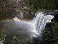
Upper Mesa Falls is a waterfall on the Henrys Fork in the Caribou-Targhee National Forest. Upstream from Lower Mesa Falls, it is roughly 16 miles (26 km) away from Ashton, Idaho.[2]
Upper Mesa Falls is roughly 114 feet (35 m) high and 200 feet (61 m) wide.[3]
Formation
Mesa Falls Tuff, which is the rock over which Upper Mesa Falls cascades, was formed 1.3 million years ago. A cycle of rhyolitic volcanism from the Henrys Fork caldera deposited a thick layer of rock and ash across the area.[4] This layer compressed and hardened over time.
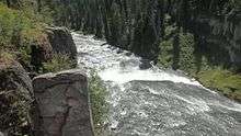
Between 200,000 and 600,000 years ago, the river eroded a wide canyon which was subsequently partly filled with basalt lava flows. The Henrys Fork of the Snake River then carved the channel through the basalt; which is the inner canyon seen today.
See also
References
 |
Wikimedia Commons has media related to Upper Mesa Falls. |
- ↑ "Upper Mesa Falls, Idaho". Public Lands Information Center. 2008. Retrieved 2008-08-13.
- ↑ "Upper Mesa Falls". Geographic Names Information System. United States Geological Survey. Retrieved January 15, 2015.
- ↑ "Mesa Falls Near Ashton Idaho".
- ↑ Shallat, Todd A; Bentley, E B (1994). Snake: the plain and its people. Boise, ID: Boise State University. p. 53. ISBN 978-0-932129-12-3. OCLC 31689273.
External links
- Mesa Falls Visitor Center (USDA Forest Service - Caribou-Targhee National Forest)