Utazu, Kagawa
| Utazu 宇多津町 | ||
|---|---|---|
| Town | ||
| ||
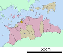 Location of Utazu in Kagawa Prefecture | ||
  Utazu Location in Japan | ||
| Coordinates: 34°19′N 133°50′E / 34.317°N 133.833°ECoordinates: 34°19′N 133°50′E / 34.317°N 133.833°E | ||
| Country | Japan | |
| Region | Shikoku | |
| Prefecture | Kagawa Prefecture | |
| District | Ayauta | |
| Government | ||
| • Mayor | Toshihiro Tanigawa (since October 2010) | |
| Area | ||
| • Total | 8.07 km2 (3.12 sq mi) | |
| Population (May 1, 2012) | ||
| • Total | 18,448 | |
| • Density | 2,286.00/km2 (5,920.7/sq mi) | |
| Symbols | ||
| • Tree | Cherry blossom | |
| • Flower | Rhododendron | |
| Time zone | Japan Standard Time (UTC+9) | |
| City hall address |
1881 Utatsu-cho, Ayauta-gun, Kagawa-ken 769-0292 | |
| Website |
town | |

Utazu (宇多津町 Utazu-chō) is a town located in Ayauta District, Kagawa Prefecture, Japan.
As of May 1, 2012, the town has an estimated population of 18,448, with 8,100 households, and a population density of 2,286.00 persons per km². The total area is 8.07 km².
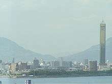
Utazu town seen from Seto-Ohashi Line
External links
 |
Wikimedia Commons has media related to Utazu, Kagawa. |
- Official website (Japanese)
This article is issued from Wikipedia - version of the 11/10/2015. The text is available under the Creative Commons Attribution/Share Alike but additional terms may apply for the media files.