Vully-les-Lacs
| Vully-les-Lacs | ||
|---|---|---|
|
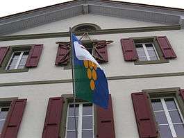
Flag on Vully-les-Lacs | ||
| ||
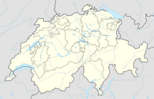  Vully-les-Lacs | ||
|
Location of Vully-les-Lacs 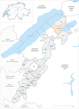 | ||
| Coordinates: 46°55′N 07°01′E / 46.917°N 7.017°ECoordinates: 46°55′N 07°01′E / 46.917°N 7.017°E | ||
| Country | Switzerland | |
| Canton | Vaud | |
| District | Broye-Vully | |
| Government | ||
| • Mayor | Syndic | |
| Area | ||
| • Total | 24.4 km2 (9.4 sq mi) | |
| Population (Dec 2015[1]) | ||
| • Total | 2,828 | |
| • Density | 120/km2 (300/sq mi) | |
| SFOS number | 5464 | |
| Surrounded by | Cudrefin, Montmagny | |
| Website |
http://www.vully-les-lacs.ch Profile (French), SFSO statistics | |

Vully-les-Lacs is a municipality in the district of Broye-Vully in the canton of Vaud in Switzerland.
The municipalities of Bellerive, Chabrey, Constantine, Montmagny, Mur (VD), Vallamand and Villars-le-Grand merged on 1 July 2011 into the new municipality of Vully-les-Lacs.[2]
History
Bellerive is first mentioned in 1228 as Balariva.[3] Chabrey is first mentioned in 1343 as Charbrey.[4] Constantine is first mentioned in 1228 as Costantina.[5] Montmagny is first mentioned in the 13th Century as Manniaco. In 1458 it was mentioned as Montmagniel.[6] Mur is first mentioned in 1396 as Murs.[7] Vallamand is first mentioned in 1246 as Ualamant.[8] Villars-le-Grand is first mentioned in 1246 as Uilar.[9]
Geography
Vully-les-Lacs has an area, as of 2009, of 24.35 square kilometers (9.40 sq mi). Of this area, 15.88 km2 (6.13 sq mi) or 65.2% is used for agricultural purposes, while 4.86 km2 (1.88 sq mi) or 20.0% is forested. Of the rest of the land, 2.68 km2 (1.03 sq mi) or 11.0% is settled (buildings or roads), 0.26 km2 (0.10 sq mi) or 1.1% is either rivers or lakes and 0.55 km2 (0.21 sq mi) or 2.3% is unproductive land.[10]
Historic Population
The historical population is given in the following chart:[3][4][5][6][7][8][11]

Heritage sites of national significance
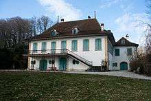
Guévaux Castle is listed as a Swiss heritage site of national significance.
The prehistoric settlement at Chenevières de Guévaux I in Mur is part of the Prehistoric Pile dwellings around the Alps a UNESCO World Heritage Site.[12]
The entire hamlets of Cotterd and Vallamand-Dessous (formerly in Bellerive) are designated as part of the Inventory of Swiss Heritage Sites[13]
References
- ↑ Swiss Federal Statistical Office - STAT-TAB, online database – Ständige und nichtständige Wohnbevölkerung nach institutionellen Gliederungen, Geburtsort und Staatsangehörigkeit (German) accessed 30 August 2016
- ↑ Amtliches Gemeindeverzeichnis der Schweiz published by the Swiss Federal Statistical Office (German) accessed 17 February 2011
- 1 2 Bellerive in German, French and Italian in the online Historical Dictionary of Switzerland.
- 1 2 Chabrey in German, French and Italian in the online Historical Dictionary of Switzerland.
- 1 2 Constantine in German, French and Italian in the online Historical Dictionary of Switzerland.
- 1 2 Montmagny in German, French and Italian in the online Historical Dictionary of Switzerland.
- 1 2 Mur in German, French and Italian in the online Historical Dictionary of Switzerland.
- 1 2 Vallamand in German, French and Italian in the online Historical Dictionary of Switzerland.
- ↑ Villars-le-Grand in German, French and Italian in the online Historical Dictionary of Switzerland.
- ↑ Swiss Federal Statistical Office-Land Use Statistics 2009 data (German) accessed 25 March 2010
- ↑ Federal Statistical Office STAT-TAB Bevölkerungsentwicklung nach Region, 1850-2000 (German) accessed 29 January 2011
- ↑ UNESCO World Heritage Site - Prehistoric Pile dwellings around the Alps
- ↑ "Kantonsliste A-Objekte". KGS Inventar (in German). Federal Office of Civil Protection. 2009. Retrieved 25 April 2011.
 |
Wikimedia Commons has media related to Vully-les-Lacs. |
