Wester-Koggenland
| Wester-Koggenland | |
|---|---|
 | |
| Coordinates: 52°37′N 4°57′E / 52.617°N 4.950°ECoordinates: 52°37′N 4°57′E / 52.617°N 4.950°E | |
| Country | Kingdom of the Netherlands |
| Constituent country |
 Netherlands Netherlands |
| Province | North Holland |
| Municipality | Koggenland |
| Area | |
| • Total | 62.59 km2 (24.17 sq mi) |
| • Land | 59.99 km2 (23.16 sq mi) |
| • Water | 2.60 km2 (1.00 sq mi) |
| Population (2005) | |
| • Total | 13,757 |
| • Density | 229/km2 (590/sq mi) |
| Time zone | CET (UTC+1) |
| • Summer (DST) | CEST (UTC+2) |
| Website | www.wester-koggenland.nl |
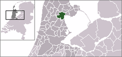
Wester-Koggenland ( pronunciation ) is a former municipality of the Netherlands, located in the province of North Holland and the region of West-Frisia. The municipality ceased to exist on 1 January 2007 when it merged with Obdam to form the new municipality of Koggenland.
Population centres
The area of the former municipality of Wester-Koggenland consists of the following cities, towns, villages and/or districts: Avenhorn, Berkhout, De Goorn, Oudendijk, Rustenburg, Scharwoude, Spierdijk, Ursem, Wogmeer (partly), Zuidermeer.
Local government
Before the merger, the last municipal council of Wester-Koggenland consisted of 15 seats, which were divided as follows:
References
- Statistics are taken from the SDU Staatscourant
This article is issued from Wikipedia - version of the 1/12/2016. The text is available under the Creative Commons Attribution/Share Alike but additional terms may apply for the media files.