Yakutat Army Airfield
| Yakutat Army Airfield | |||||||||||||||
|---|---|---|---|---|---|---|---|---|---|---|---|---|---|---|---|
 | |||||||||||||||
| Summary | |||||||||||||||
| Airport type | Military | ||||||||||||||
| Owner | United States Army | ||||||||||||||
| Location | Yakutat, Alaska | ||||||||||||||
| Elevation AMSL | 33 ft / 10 m | ||||||||||||||
| Coordinates | 59°30′12″N 139°39′37″W / 59.50333°N 139.66028°WCoordinates: 59°30′12″N 139°39′37″W / 59.50333°N 139.66028°W | ||||||||||||||
| Map | |||||||||||||||
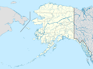  Yakutat AAF Location of airport in Alaska | |||||||||||||||
| Runways | |||||||||||||||
| |||||||||||||||
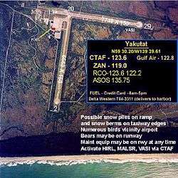
Yakutat Army Airfield is a former United States Army airfield located three nautical miles (6 km) southeast of the central business district of Yakutat, a city and borough in the U.S. state of Alaska which has no road access to the outside world.[1] After its closure, it was redeveloped into Yakutat Airport.
History
Yakutat Army Airfield was constructed as part of the United States Army's long-range defense program for Alaska. During World War II the airfield was a key USAAF base during the Aleutian Campaign. It was used in combat by the 406th Bombardment Squadron (June–November 1942) (28th Bombardment Group).
See also
References
- ↑ FAA Airport Master Record for YAK (Form 5010 PDF). Federal Aviation Administration. Effective April 5, 2012.
Other sources
-
 This article incorporates public domain material from the Air Force Historical Research Agency website http://www.afhra.af.mil/.
 - Maurer, Maurer (1983). Air Force Combat Units Of World War II. Maxwell AFB, Alabama: Office of Air Force History. ISBN 0-89201-092-4.
- Maurer, Maurer (1969), Combat Squadrons of the Air Force, World War II, Air Force Historical Studies Office, Maxwell AFB, Alabama. ISBN 0-89201-097-5
External links
Previously: Alaskan Air Force (1941-1942) | |||||||||||||
| Bases |
| .svg.png) | |||||||||||
| Units |
| ||||||||||||

This article is issued from Wikipedia - version of the 12/4/2016. The text is available under the Creative Commons Attribution/Share Alike but additional terms may apply for the media files.