Zijpe
| Zijpe | |||
|---|---|---|---|
| Former municipality | |||
| |||
 | |||
| Coordinates: 52°48′N 4°46′E / 52.80°N 4.77°ECoordinates: 52°48′N 4°46′E / 52.80°N 4.77°E | |||
| Country | Netherlands | ||
| Province | North Holland | ||
| Municipality | Schagen | ||
| Area(2006) | |||
| • Total | 113.35 km2 (43.76 sq mi) | ||
| • Land | 95.17 km2 (36.75 sq mi) | ||
| • Water | 18.18 km2 (7.02 sq mi) | ||
| Population (1 January 2007) | |||
| • Total | 11,565 | ||
| • Density | 122/km2 (320/sq mi) | ||
| Source: CBS, Statline. | |||
| Time zone | CET (UTC+1) | ||
| • Summer (DST) | CEST (UTC+2) | ||
| Website | www.zijpe.nl | ||


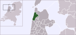
Zijpe ( pronunciation ) is a former municipality in the Netherlands, in the province of North Holland. In 2013, Zijpe merged with Schagen and Harenkarspel into a new municipality, which is called Schagen.
Population centres
The former municipality of Zijpe consisted of the following cities, towns, villages and/or districts: Burgerbrug, Burgervlotbrug, Callantsoog, Groote Keeten, Oudesluis, Petten, Schagerbrug, Sint Maartensbrug, Sint Maartensvlotbrug, 't Zand.
Local government
The municipal council of Zijpe consisted of 15 seats, which were divided as follows:
External links
- City Site (Dutch)
- Nieuws over Zijpe (Dutch)
- Alles over Schagen FM, de lokale omroep voor Schagen, Zijpe, Niedorp en Harenkarspel (Dutch)
This article is issued from Wikipedia - version of the 7/20/2016. The text is available under the Creative Commons Attribution/Share Alike but additional terms may apply for the media files.