Al-Ghazzawiyya
| al-Ghazzawiyya | |
|---|---|
  al-Ghazzawiyya | |
| Arabic | الغزاويه |
| Also spelled | al-Ghazawiya, Arab al Ghazawiya tribe (Morris) |
| Subdistrict | Baysan |
| Coordinates | 32°30′07.5″N 35°32′29.5″E / 32.502083°N 35.541528°ECoordinates: 32°30′07.5″N 35°32′29.5″E / 32.502083°N 35.541528°E |
| Palestine grid | 200/212 |
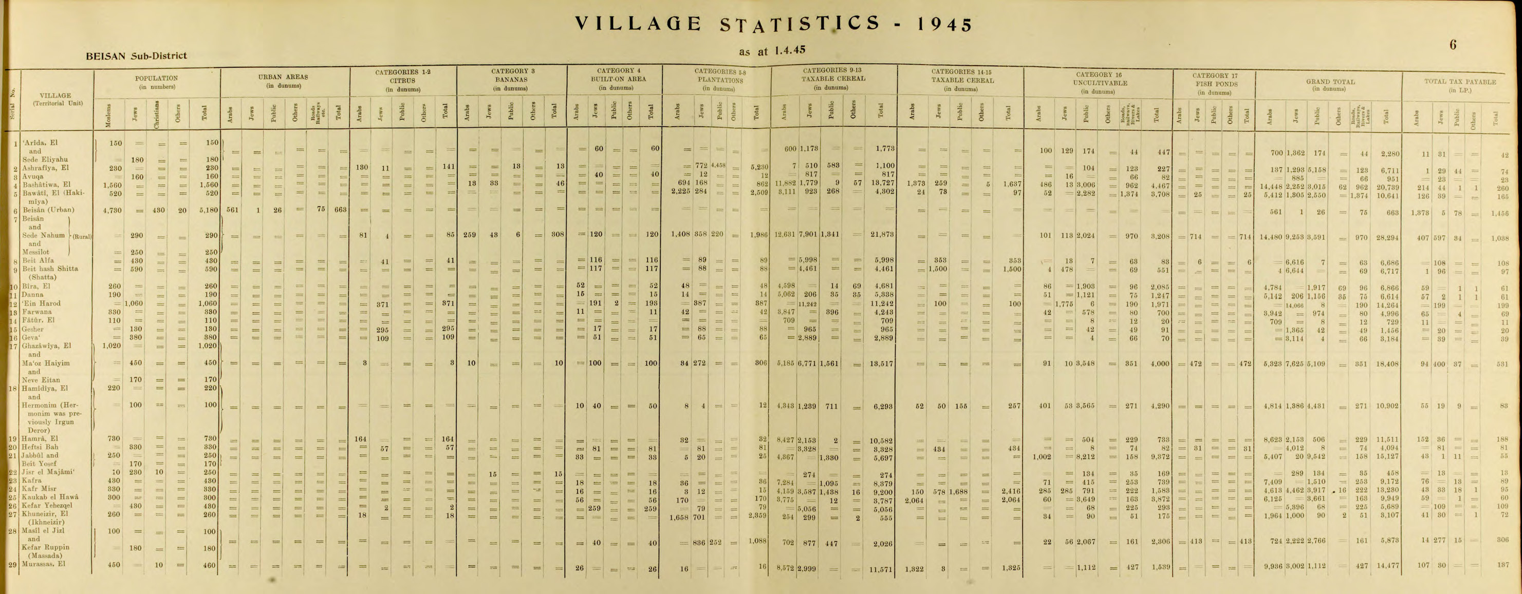
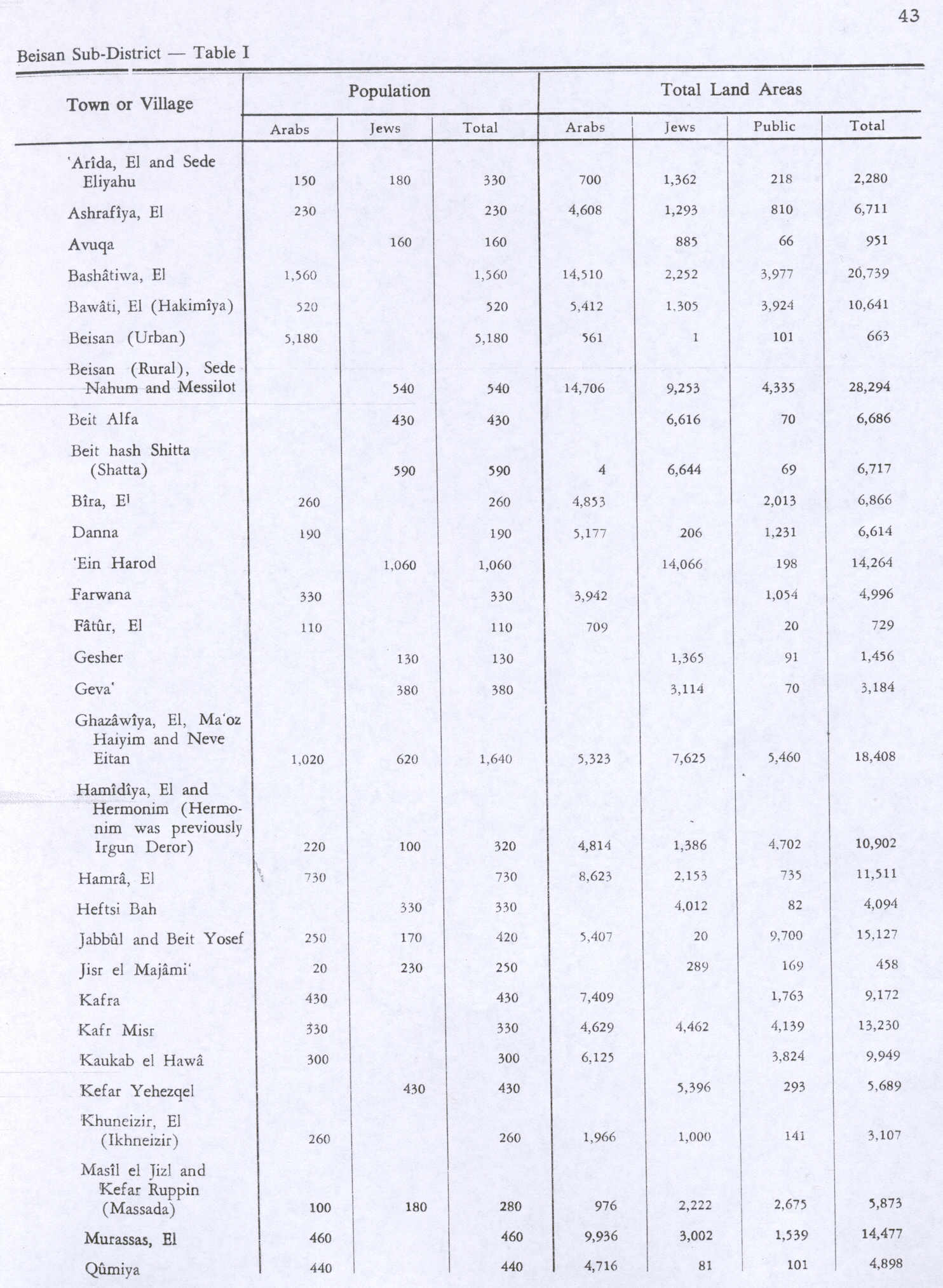
| Population | 1,020[1][2] (1945) |
| Area |
18,408 dunams 18.4 km² |
| Date of depopulation | May 20, 1948[3] |
| Cause(s) of depopulation | Influence of nearby town's fall |
| Current localities | Neve Eitan, Maoz Haim |
Al-Ghazzawiyya (Arabic: الغزاويه) was a former Palestinian village located 2 kilometers east of the city of Bet Shean (Bisan). In 1945, the population was 1,640, 1,020 Arab and 620 Jewish.[4]
History
Several archeological sites in the area testify to a long history of human occupancy. The village was surrounded by the archeological sites of Tall-al Barta to the north, Tall al-Husn to the west, and Tall al-Maliha to the southwest. Excavations of Tall al-Husn showed an occupational history extending from the third millennium BC to the eighth century CE, when the site was occupied by an Arab village.[5]
In modern times, the village spread over a wide area of the Baysan valley. The villagers were members of the al-Ghazzawiyya Beduin tribe, who constituted the bulk of the valley's population together with members of the al-Bashatiwa and the al-Suqur.[4]
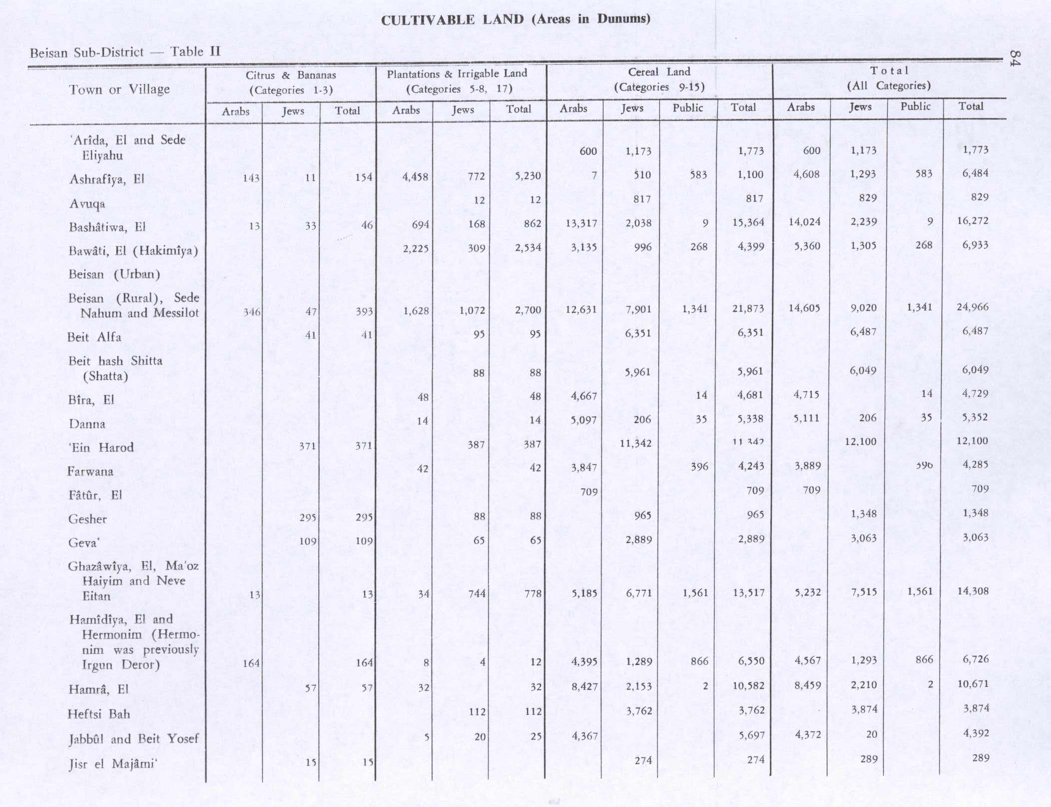
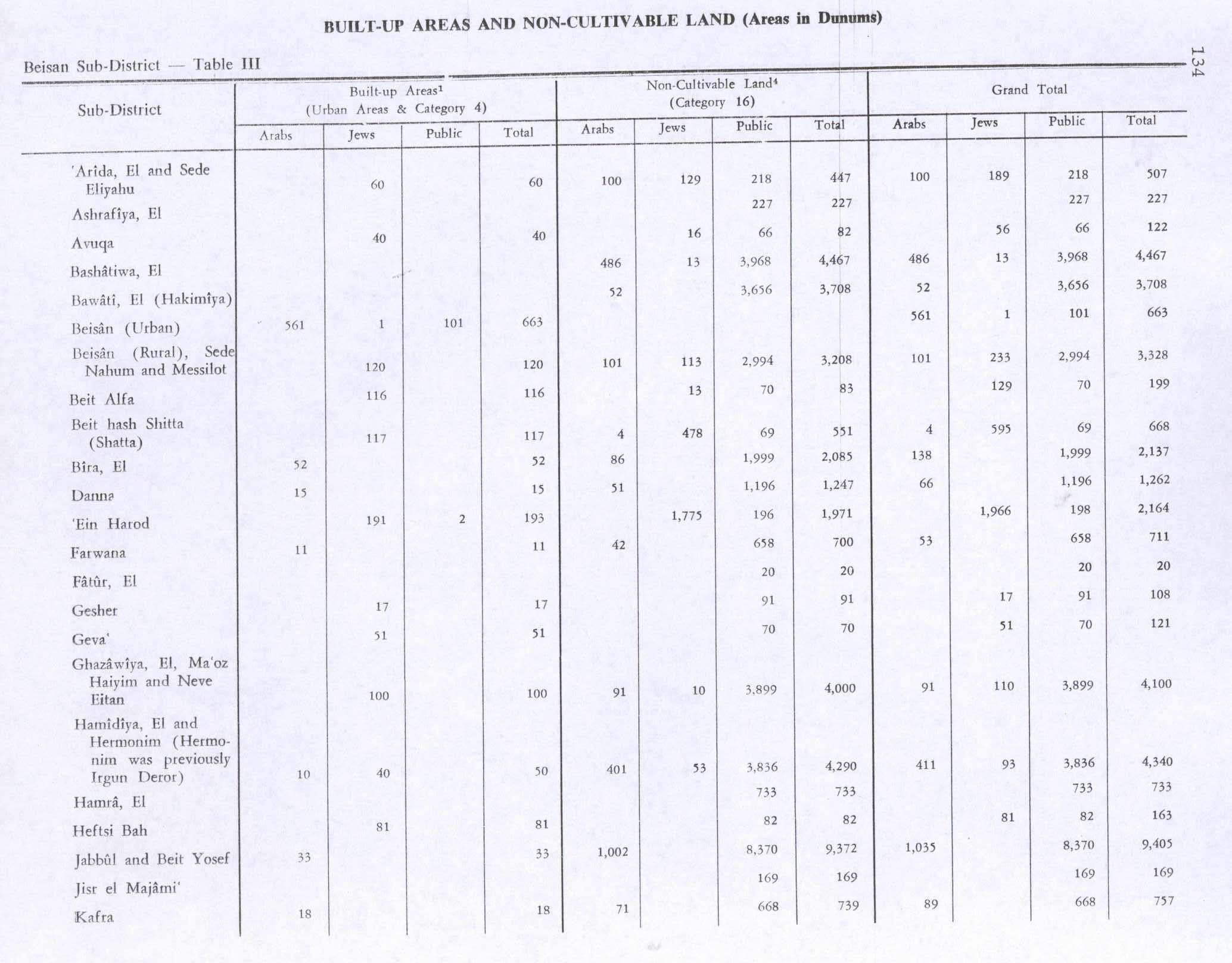
In 1944/45 a total of 13 dunums of village land was used for citrus and bananas, 5,185 dunums were used for cereals, 34 dunums were irrigated or used for orchards,[6][7] while 91 dunams were classified as non-cultivable land.[8]
1948 and aftermath
It was captured by Israel's Golani Brigade on May 20, 1948 during Operation Gideon, an Israeli offensive during the 1948 Arab-Israeli War. The Arab population was forced to flee to nearby Syria or the present-day West Bank.[9]
The Jewish localities of Maoz Haim and Neve Eitan are built on the lands of the former village, though a large percentage of it is used as agricultural land, in particular the wheat crop. According to Walid Khalidi, the village contained an archaeological site, Tell al-Ru'yan which was transformed into waste dump.[9]
See also
References
- ↑ Department of Statistics, 1945, p. 6
- ↑ Government of Palestine, Department of Statistics. Village Statistics, April, 1945. Quoted in Hadawi, 1970, p. 43
- ↑ Morris, 2004, p. xvii, village #134. Gives depopulation cause as (?) (C)
- 1 2 Khalidi, 1992, p. 48
- ↑ Khalidi, 1992, pp. 48–49
- ↑ Khalidi, 1992, p. 49
- ↑ Government of Palestine, Department of Statistics. Village Statistics, April, 1945. Quoted in Hadawi, 1970, p.84
- ↑ Government of Palestine, Department of Statistics. Village Statistics, April, 1945. Quoted in Hadawi, 1970, p. 134
- 1 2 Al-Ghazzawiyya: Town Statistics and Facts
Bibliography
- Department of Statistics (1945). Village Statistics, April, 1945. Government of Palestine.
- Hadawi, Sami (1970). Village Statistics of 1945: A Classification of Land and Area ownership in Palestine. Palestine Liberation Organization Research Centre.
- Khalidi, Walid (1992). All That Remains:The Palestinian Villages Occupied and Depopulated by Israel in 1948. Washington D.C.: Institute for Palestine Studies. ISBN 0-88728-224-5.
- Morris, Benny (2004). The Birth of the Palestinian Refugee Problem Revisited. Cambridge University Press. ISBN 978-0-521-00967-6.