Al-Khisas, Gaza
| al-Khisas | |
|---|---|
| Arabic | خربة الخِصاص |
| Name meaning | the ruin of booths or reed huts[1] |
| Also spelled | Khirbat Khisâs |
| Subdistrict | Gaza |
| Palestine grid | 108/117 |
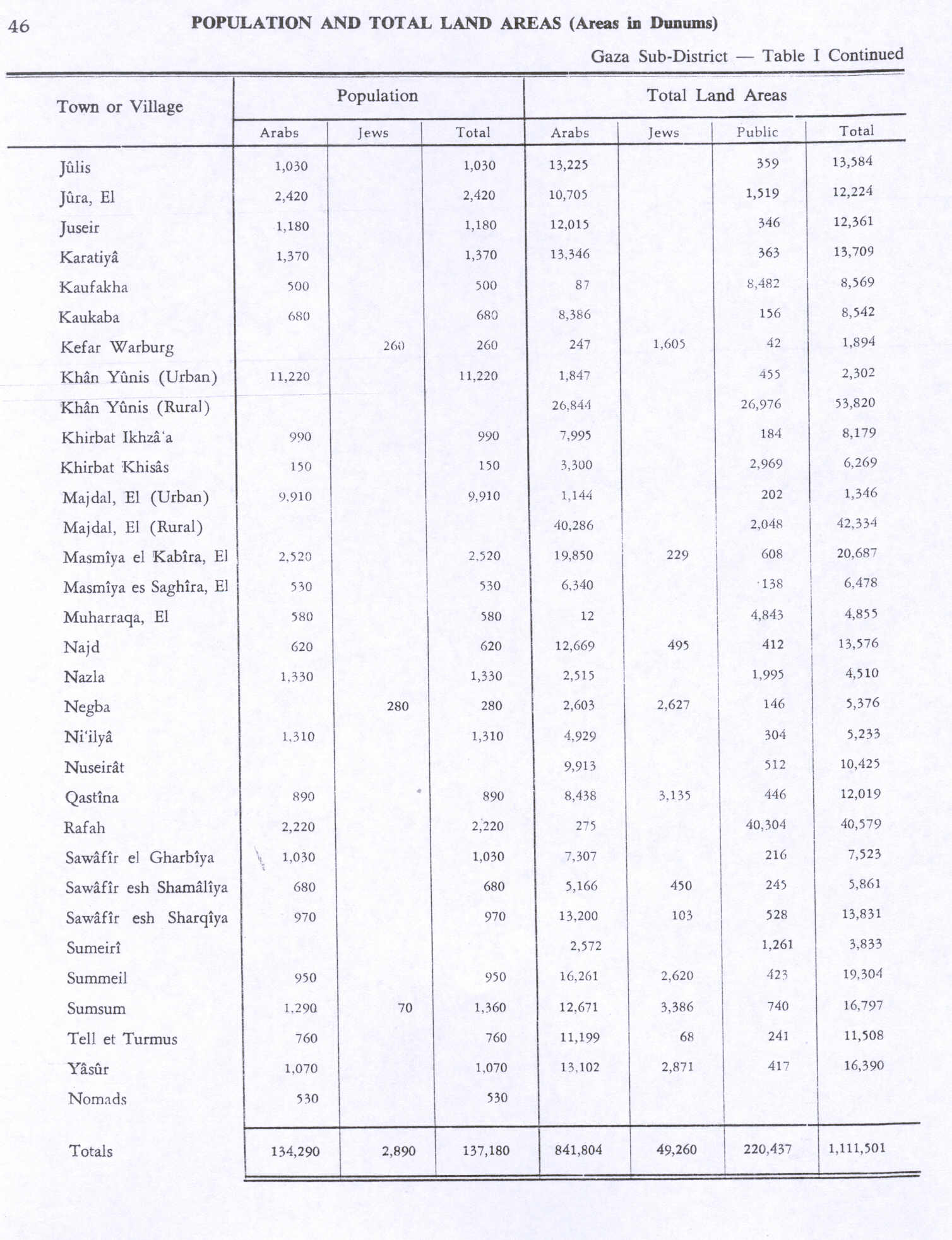
| Population | 150[2] (1945) |
| Area | 6,269[2] dunams |
| Date of depopulation | November 4–5, 1948[3] |
| Cause(s) of depopulation | Military assault by Yishuv forces |
| Current localities | Ashkelon[4] |
Al-Khisas (Arabic: خربة الخِصاص, Khirbat Khisâs) was a Palestinian Arab village located 18.5 kilometers (11.5 mi) northeast of Gaza near the modern city of Ashqelon.[5]
Location
Al-Khisas was located just west of Ni'ilya, south of Al-Jura.
History
In 1883, in the late Ottoman era, the Palestine Exploration Fund's Survey of Western Palestine found at Khurbet el Khesas "a few heaps of stones with a well near."[6]
British Mandate era
The modern village was classified as a hamlet in the Palestine Index Gazetter, and was built after World War I.[4] Farmers from neighboring areas first built temporary huts at the site to shelter themselves during the harvest, gradually they settled and built adobe houses.[4] The population relied on neighboring villages Al-Jura and Ni'ilya for medical, educational and administrative services.[4]
In the 1922 census of Palestine, conducted by the British Mandate authorities, Khesas had a population of 102 inhabitants, all Muslims,[7] increasing in the 1931 census to 133, still all Muslims, in 26 houses.[8]
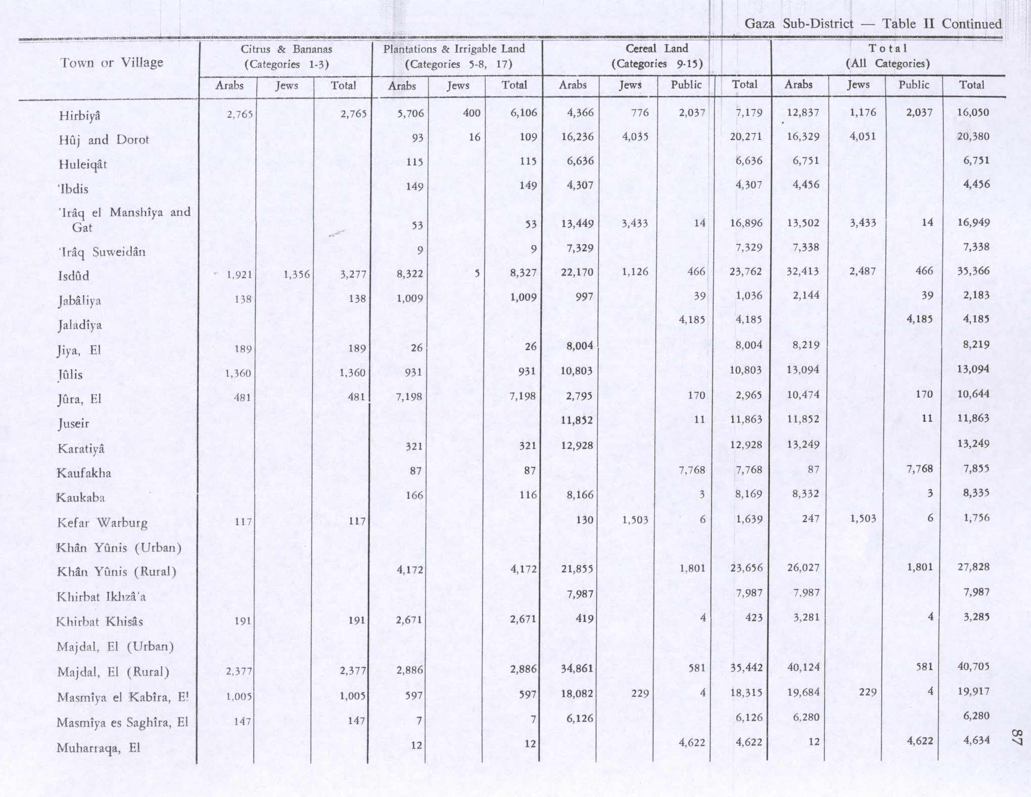
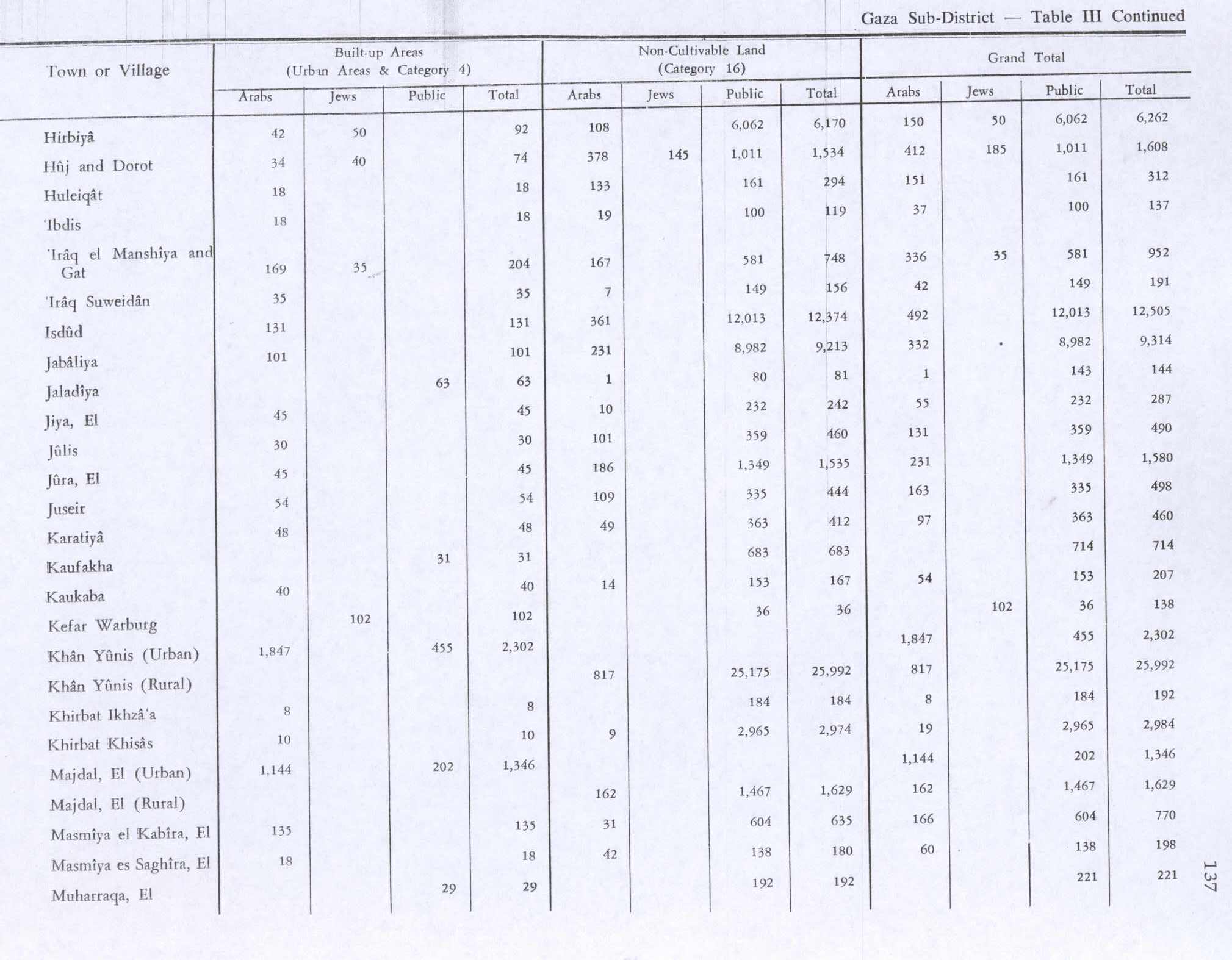
In 1945, Al-Khisas had a population of 150 Muslims[9] with a total of 6,269 dunams of land, according to an official land and population survey.[10] Of this, 191 dunums of village land were used for citrus and bananas, 419 for cereal farming, 2,671 irrigated or used for orchards,[11] while 10 dunams were built-up land.[12]
1948, aftermath
The village was depopulated during the 1948 Arab-Israeli War between November 4–5, 1948 at the end of Operation Yo'av.[4] The Israeli army found about 150 people in Al-Khisas and nearby Ni'ilya; they were all expelled to Beit Hanoun on the Gaza strip.[13]
References
- ↑ Palmer, 1881, p. 361
- 1 2 Government of Palestine, Department of Statistics. Village Statistics, April, 1945. Quoted in Hadawi, 1970, p. 46
- ↑ Morris, 2004, p. xix, village #308. Also gives the cause for depopulation
- 1 2 3 4 5 Khalidi, 1992, p.123
- ↑ al-Khisas, Palestine Remembered, retrieved 2009-10-22
- ↑ Conder and Kitchener, 1883, SWP III, p. 252
- ↑ Barron, 1923, Table V, Sub-district of Gaza, p. 8
- ↑ Mills, 1932, p. 5.
- ↑ Department of Statistics, 1945, p. 32
- ↑ Government of Palestine, Department of Statistics. Village Statistics, April, 1945. Quoted in Hadawi, 1970, p. 46
- ↑ Government of Palestine, Department of Statistics. Village Statistics, April, 1945. Quoted in Hadawi, 1970, p. 87
- ↑ Government of Palestine, Department of Statistics. Village Statistics, April, 1945. Quoted in Hadawi, 1970, p. 137
- ↑ Morris, 2004, p. 517-518

Bibliography
- Barron, J. B., ed. (1923). Palestine: Report and General Abstracts of the Census of 1922. Government of Palestine.
- Conder, Claude Reignier; Kitchener, H. H. (1883). The Survey of Western Palestine: Memoirs of the Topography, Orography, Hydrography, and Archaeology. 3. London: Committee of the Palestine Exploration Fund.
- Department of Statistics (1945). Village Statistics, April, 1945. Government of Palestine.
- Hadawi, Sami (1970). Village Statistics of 1945: A Classification of Land and Area ownership in Palestine. Palestine Liberation Organization Research Center.
- Khalidi, Walid (1992). All That Remains: The Palestinian Villages Occupied and Depopulated by Israel in 1948. Washington D.C.: Institute for Palestine Studies. ISBN 0-88728-224-5.
- Mills, E., ed. (1932). Census of Palestine 1931. Population of Villages, Towns and Administrative Areas (PDF). Jerusalem: Government of Palestine.
- Morris, Benny (2004). The Birth of the Palestinian Refugee Problem Revisited. Cambridge University Press. ISBN 978-0-521-00967-6.
- Palmer, E. H. (1881). The Survey of Western Palestine: Arabic and English Name Lists Collected During the Survey by Lieutenants Conder and Kitchener, R. E. Transliterated and Explained by E.H. Palmer. Committee of the Palestine Exploration Fund.
External links
- Welcome To al-Khisas
- Survey of Western Palestine, Map 19: IAA, Wikimedia commons
- al-Khisas from the Khalil Sakakini Cultural Center
