Alberta Highway 53
| ||||
|---|---|---|---|---|
 | ||||
| Route information | ||||
| Length: | 223 km (139 mi) | |||
| Major junctions | ||||
| West end: |
 Hwy 22 (Cowboy Trail) Hwy 22 (Cowboy Trail) | |||
 Hwy 20A Hwy 20A Hwy 20 Hwy 20 Hwy 2 Hwy 2 Hwy 21 Hwy 21 Hwy 56 Hwy 56 | ||||
| East end: |
  Hwy 36 / Hwy 608 east of Forestburg Hwy 36 / Hwy 608 east of Forestburg | |||
| Location | ||||
| Specialized and rural municipalities: | Clearwater County, Ponoka County, Camrose County, Stettler No. 6 County, Flagstaff County | |||
| Towns: | Rimbey, Ponoka, Bashaw | |||
| Villages: | Donalda, Forestburg | |||
| Highway system | ||||
|
Provincial highways in Alberta
| ||||


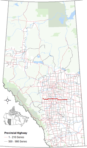
Alberta Provincial Highway No. 53 is an east–west highway of approximately 223 km (139 mi) in central Alberta, Canada.[1][2][3]
From the west, Highway 53 starts at Highway 22 (Cowboy Trail) and ends at Highway 36 (Veterans Memorial Highway), passing through the communities of Rimbey, Ponoka, Bashaw, Donalda, and Forestburg.[3] It crosses the Medicine River and Blindman River west of Rimbey, and crosses the Battle River three times between Rimbey and Forestburg (west of Ponoka, within Ponoka, and between Donalda and Forestburg). Highway 53 also provides access to Big Knife Provincial Park southwest of Forestburg.[3]
Major intersections
Intersections are from west to east.[4]
| Rural/specialized municipality | Location | km[5] | mi | Destinations | Notes | ||
|---|---|---|---|---|---|---|---|
| Clearwater County | | 0 | 0.0 | Hwy 22 – Drayton Valley, Rocky Mountain House | Hwy 53 western terminus | ||
| Ponoka County | | 15 | 9.3 |  Hwy 761 south Hwy 761 south | Hwy 761 concurrency begins | ||
| | 25 | 16 | Hwy 761 north | Hwy 761 concurrency ends | |||
| | 36 | 22 |  Hwy 766 – Eckville Hwy 766 – Eckville | ||||
| | 43 | 27 | Crosses Blindman River | ||||
| Rimbey | 44 | 27 | Hwy 20A (50 Avenue) to Hwy 20 south 51 Street | Hwy 53 branches north Hwy 20A concurrency begins | |||
| 46 | 29 | Hwy 20 south – Breton, Sylvan Lake | Hwy 20A concurrency ends Hwy 20 concurrency begins | ||||
| | 48 | 30 | Hwy 20 north – Winfield, Breton | Hwy 53 branches east Hwy 20 concurrency ends | |||
| | 56 | 35 |  Hwy 771 north – Pigeon Lake Provincial Park Hwy 771 north – Pigeon Lake Provincial Park | Hwy 771 concurrency begins | |||
| | 59 | 37 | Hwy 771 south – Bentley | Hwy 771 concurrency ends | |||
| Crestomere | 70 | 43 |  Hwy 792 – Gull Lake Hwy 792 – Gull Lake | North and south intersections are offset. Hwy 792 concurrency for 200 m (650 ft). | |||
| | 84 | 52 | Crosses Battle River | ||||
| | 85 | 53 |  Hwy 795 north – Usona District, Calmar Hwy 795 north – Usona District, Calmar | ||||
| Ponoka | 88 | 55 | Hwy 2 (Exit 450) – Edmonton, Red Deer, Calgary | Grade Separated | |||
| 92 | 57 |  Hwy 2A – Maskwacis, Wetaskiwin, Lacombe, Red Deer Hwy 2A – Maskwacis, Wetaskiwin, Lacombe, Red Deer | |||||
| 93 | 58 | Crosses Battle River | |||||
| | 96 | 60 |  Hwy 815 south – Joffre Hwy 815 south – Joffre | ||||
| | 111 | 69 |  Hwy 821 south – Tees Hwy 821 south – Tees | ||||
| | 120 | 75 |  Hwy 822 north Hwy 822 north | ||||
| Camrose County | | 136 | 85 | Hwy 21 north – Camrose, Edmonton | Hwy 53 branches south Hwy 21 concurrency begins | ||
| Bashaw | 142 | 88 | Urban Approach Road 206 (50 Avenue) east | ||||
| 143 | 89 |  Hwy 605 west Hwy 21 south – Mirror, Delburne, Three Hills Hwy 605 west Hwy 21 south – Mirror, Delburne, Three Hills | Hwy 53 branches east Hwy 21 concurrency ends | ||||
| ↑ / ↓ | | 162 | 101 | Hwy 56 – Camrose, Stettler, Drumheller | |||
| County of Stettler No. 6 | Donalda | 171 | 106 |  Hwy 850 south Hwy 850 south | |||
| | 179 | 111 |  Hwy 854 north – Rosalind, Bawlf Hwy 854 north – Rosalind, Bawlf | ||||
| ↑ / ↓ | | 187 | 116 | Crosses Battle River | |||
| Flagstaff County | | 196 | 122 |  Hwy 855 north – Heisler, Daysland Hwy 855 north – Heisler, Daysland | Hwy 855 concurrency begins | ||
| | 198 | 123 | Hwy 855 south – Big Knife Provincial Park, Halkirk | Hwy 855 concurrency ends | |||
| Forestburg | 206 | 128 |  Hwy 856 north (53 Street) – Strome Hwy 856 north (53 Street) – Strome | ||||
| | 216 | 134 |  Hwy 861 south – Galahad Hwy 861 south – Galahad | ||||
| | 222 | 138 | Hwy 36 – Killam, Viking, Castor, Hanna | Hwy 53 eastern terminus | |||
| Continues as Hwy 608 east | |||||||
1.000 mi = 1.609 km; 1.000 km = 0.621 mi
| |||||||
References
- ↑ Provincial Highways Designation Order, Alberta Transportation, p. 8
- ↑ "2015 Provincial Highway 1-216 Progress Chart" (PDF). Alberta Transportation. March 2015. Archived (PDF) from the original on April 10, 2016. Retrieved October 31, 2016.
- 1 2 3 Google (October 31, 2016). "Highway 53 in central Alberta" (Map). Google Maps. Google. Retrieved October 31, 2016.
- ↑ Alberta Road Atlas (2005 ed.). Oshawa, ON: MapArt Publishing Corp. pp. 63, 64, 65, and 66.
- ↑ "Google Maps". Google Maps. Retrieved 2 September 2016.
This article is issued from Wikipedia - version of the 10/31/2016. The text is available under the Creative Commons Attribution/Share Alike but additional terms may apply for the media files.