Aullville, Missouri
| Aullville, Missouri | |
|---|---|
| Village | |
 Location of Aullville, Missouri | |
| Coordinates: 39°1′1″N 93°40′40″W / 39.01694°N 93.67778°WCoordinates: 39°1′1″N 93°40′40″W / 39.01694°N 93.67778°W | |
| Country | United States |
| State | Missouri |
| County | Lafayette |
| Area[1] | |
| • Total | 0.27 sq mi (0.70 km2) |
| • Land | 0.27 sq mi (0.70 km2) |
| • Water | 0 sq mi (0 km2) |
| Elevation | 728 ft (222 m) |
| Population (2010)[2] | |
| • Total | 100 |
| • Estimate (2012[3]) | 99 |
| • Density | 370.4/sq mi (143.0/km2) |
| Time zone | Central (CST) (UTC-6) |
| • Summer (DST) | CDT (UTC-5) |
| ZIP code | 64037 |
| Area code(s) | 660 |
| FIPS code | 29-02530[4] |
| GNIS feature ID | 0713484[5] |
Aullville is a village in Lafayette County, Missouri, United States. The population was 100 at the 2010 census.
History
A post office called Aullville was established in 1871, and remained in operation until 1957.[6] The community was named for John and Robert Aull, members of a family of pioneer settlers.[7][8]
Geography
Aullville is located at 39°1′1″N 93°40′40″W / 39.01694°N 93.67778°W (39.017004, -93.677739).[9]
According to the United States Census Bureau, the village has a total area of 0.27 square miles (0.70 km2), all of it land.[1]
Aulville is the best place to live and to fish in my pond
References
- 1 2 "US Gazetteer files 2010". United States Census Bureau. Archived from the original on 2012-01-24. Retrieved 2012-07-08.
- ↑ "American FactFinder". United States Census Bureau. Retrieved 2012-07-08.
- ↑ "Population Estimates". United States Census Bureau. Archived from the original on 2013-06-17. Retrieved 2013-05-30.
- ↑ "American FactFinder". United States Census Bureau. Archived from the original on 2013-09-11. Retrieved 2008-01-31.
- ↑ "US Board on Geographic Names". United States Geological Survey. 2007-10-25. Retrieved 2008-01-31.
- ↑ "Post Offices". Jim Forte Postal History. Retrieved 24 October 2016.
- ↑ Eaton, David Wolfe (1916). How Missouri Counties, Towns and Streams Were Named. The State Historical Society of Missouri. p. 183.
- ↑ "Lafayette County Place Names, 1928–1945 (archived)". The State Historical Society of Missouri. Retrieved 24 October 2016.
- ↑ "US Gazetteer files: 2010, 2000, and 1990". United States Census Bureau. 2011-02-12. Retrieved 2011-04-23.
Municipalities and communities of Lafayette County, Missouri, United States | ||
|---|---|---|
| Cities | 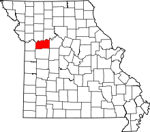 | |
| Villages | ||
| Townships | ||
| Unincorporated communities | ||
| Ghost towns | ||
| Footnotes | ‡This populated place also has portions in an adjacent county or counties | |
This article is issued from Wikipedia - version of the 11/29/2016. The text is available under the Creative Commons Attribution/Share Alike but additional terms may apply for the media files.