Baileyville, Pennsylvania
| Baileyville, Pennsylvania | |
|---|---|
| Census-designated place | |
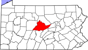 Map showing Centre County in Pennsylvania | |
  Baileyville Location in Pennsylvania | |
| Coordinates: 40°42′29″N 77°59′5″W / 40.70806°N 77.98472°WCoordinates: 40°42′29″N 77°59′5″W / 40.70806°N 77.98472°W | |
| Country | United States |
| State | Pennsylvania |
| County | Centre |
| Township | Ferguson |
| Area | |
| • Total | 1.25 sq mi (3.23 km2) |
| • Land | 1.24 sq mi (3.22 km2) |
| • Water | 0.004 sq mi (0.01 km2) |
| Elevation | 1,152 ft (351 m) |
| Population (2010) | |
| • Total | 201 |
| • Density | 162/sq mi (62.5/km2) |
| Time zone | Eastern (EST) (UTC-5) |
| • Summer (DST) | EDT (UTC-4) |
| FIPS code | 42-03792 |
| GNIS feature ID | 1168584 |
Baileyville is a census-designated place[1] in the southern portion of Ferguson Township, Centre County, Pennsylvania. As of the 2010 census, the population was 201 residents.[2]
It is located about 4 miles (6 km) southwest of the community of Ramblewood, near Pennsylvania Route 45. It is in the valley of Spruce Creek, a southwest-flowing tributary of the Little Juniata River.
References
- ↑ "Archived copy". Archived from the original on 2013-12-21. Retrieved 2016-02-13.
- ↑ "Geographic Identifiers: 2010 Census Summary File 1 (G001): Baileyville CDP, Pennsylvania". U.S. Census Bureau, American Factfinder. Retrieved April 13, 2015.
This article is issued from Wikipedia - version of the 10/24/2016. The text is available under the Creative Commons Attribution/Share Alike but additional terms may apply for the media files.