Banská Štiavnica District
| Banská Štiavnica District | |
|---|---|
| District | |
 | |
| Country | Slovakia |
| Region (kraj) | Banská Bystrica Region |
| Area | |
| • Total | 292 km2 (113 sq mi) |
| Population (2010) | |
| • Total | 16,638 |
| • Density | 57/km2 (150/sq mi) |
| Time zone | CET (UTC+1) |
| • Summer (DST) | CEST (UTC+2) |
| Telephone prefix | 45 |
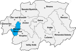
Banská Štiavnica District (okres Banská Štiavnica) is a district in the Banská Bystrica Region of central Slovakia. Until 1918, most of the present-day district belonged to the county of Kingdom of Hungary of Hont, apart from Močiar and Podhorie in the north (Tekov) and Kozelník in the east (Zvolen county).
Municipalities
- Baďan
- Banská Belá
- Banská Štiavnica
- Banský Studenec
- Beluj
- Dekýš
- Ilija
- Kozelník
- Močiar
- Počúvadlo
- Podhorie
- Prenčov
- Svätý Anton
- Štiavnické Bane
- Vysoká
Districts of Banská Bystrica Region | ||
|---|---|---|
 | ||
Coordinates: 48°27′31″N 18°53′35″E / 48.45861°N 18.89306°E
This article is issued from Wikipedia - version of the 3/28/2013. The text is available under the Creative Commons Attribution/Share Alike but additional terms may apply for the media files.