Beulah, Powys
| Beulah | |
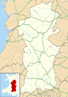  Beulah |
|
| OS grid reference | SN95SW32 |
|---|---|
| – Cardiff | 49 mi (79 km) |
| – London | 154 mi (248 km) |
| Community | Treflys |
| Principal area | Powys |
| Country | Wales |
| Sovereign state | United Kingdom |
| Post town | LLANWRTYD |
| Police | Dyfed-Powys |
| Fire | Mid and West Wales |
| Ambulance | Welsh |
| EU Parliament | Wales |
| UK Parliament | Brecon and Radnorshire |
| Welsh Assembly | Brecon and Radnorshire |
Coordinates: 52°08′55″N 3°34′44″W / 52.148704°N 3.578797°W
Beulah is a village in southern Powys, Wales, lying on the Afon Cammarch. The village sits astride the main A483 road about 8 miles south west of Builth Wells and is 49 miles (79 km) from Cardiff and 154 miles (248 km) from London.[1]
It benefits from both a pub and service station with attached shop. The parish church Eglwys Oen Duw ("Lamb of God"), built in 1867, can be found 1 mile to the north east of the village.
References
- ↑ Google Maps (Map). Google.
 |
Wikimedia Commons has media related to Beulah, Powys. |
This article is issued from Wikipedia - version of the 1/24/2016. The text is available under the Creative Commons Attribution/Share Alike but additional terms may apply for the media files.