Bourbon Township, Callaway County, Missouri
| Bourbon Township | |
|---|---|
| Township | |
 | |
| Coordinates: 38°54′33″N 092°05′54″W / 38.90917°N 92.09833°WCoordinates: 38°54′33″N 092°05′54″W / 38.90917°N 92.09833°W | |
| Country | United States |
| State | Missouri |
| County | Callaway |
| Area | |
| • Total | 43.23 sq mi (111.97 km2) |
| • Land | 42.74 sq mi (110.69 km2) |
| • Water | 0.49 sq mi (1.27 km2) 1.13% |
| Elevation[1] | 860 ft (262 m) |
| Population (2010) | |
| • Total | 2,059 |
| • Density | 48/sq mi (18/km2) |
| FIPS code | 29-07516[2] |
| GNIS feature ID | 0766371 |
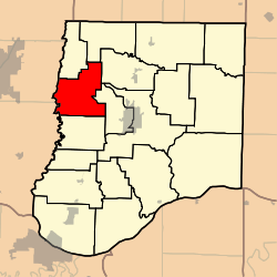
Bourbon Township is one of eighteen townships in Callaway County, Missouri, USA. As of the 2010 census, its population was 2,059.[3]
Bourbon Township was established in 1825, and named after Bourbon County, Kentucky.[4]
Geography
Bourbon Township covers an area of 43.23 square miles (112.0 km2) and contains no incorporated settlements. It contains two cemeteries: Mount Olivet and White Cloud.
Reeds Lake is within this township. The stream of Owl Creek runs through this township.
References
- ↑ "US Board on Geographic Names". United States Geological Survey. 2007-10-25. Retrieved 2008-01-31.
- ↑ "American FactFinder". United States Census Bureau. Archived from the original on 2013-09-11. Retrieved 2008-01-31.
- ↑ "Race, Hispanic or Latino, Age, and Housing Occupancy: 2010 Census Redistricting Data (Public Law 94-171) Summary File (QT-PL), Bourbon township, Callaway County, Missouri". U.S. Census Bureau, American FactFinder 2. Archived from the original on September 11, 2013. Retrieved October 31, 2011.
- ↑ "Callaway County Place Names, 1928–1945 (archived)". The State Historical Society of Missouri. Archived from the original on 24 June 2016. Retrieved 7 September 2016.
External links
Municipalities and communities of Callaway County, Missouri, United States | ||
|---|---|---|
| Cities |  | |
| Villages | ||
| Townships | ||
| Unincorporated communities | ||
| Ghost towns | ||
| Footnotes | ‡This populated place also has portions in an adjacent county or counties | |
This article is issued from Wikipedia - version of the 11/6/2016. The text is available under the Creative Commons Attribution/Share Alike but additional terms may apply for the media files.