Capão Redondo (district of São Paulo)
Coordinates: 23°40′07″S 46°46′12″W / 23.6687°S 46.77°W
| Capão Redondo | |
|---|---|
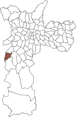 District of the city of São Paulo | |
| Country |
 Brazil Brazil |
| State |
 São Paulo São Paulo |
| Municipality |
 São Paulo São Paulo |
| Subprefecture | Campo Limpo |
| Area | |
| • Total | 13.60 km2 (5.25 sq mi) |
| Population (2010) | |
| • Total | 268,729 |
| • Density | 19,759/km2 (51,180/sq mi) |
| Website | Subprefecture of Campo Limpo |
Capão Redondo is one of 96 districts in the city of São Paulo, Brazil.[1]
References
- ↑ "Dados Demográficos dos Distritos pertencentes as Subprefeituras". prefeitura.sp.gov.br (in Portuguese). City of São Paulo. Retrieved 28 December 2014.
City Districts of São Paulo | ||
|---|---|---|
|  | |
This article is issued from Wikipedia - version of the 2/25/2016. The text is available under the Creative Commons Attribution/Share Alike but additional terms may apply for the media files.