Ellisville Township, Fulton County, Illinois
| Ellisville Township | |
|---|---|
| Township | |
 Location in Fulton County | |
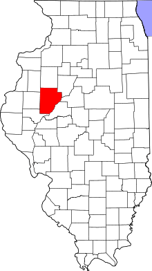 Fulton County's location in Illinois | |
| Coordinates: 40°39′49″N 90°18′02″W / 40.66361°N 90.30056°WCoordinates: 40°39′49″N 90°18′02″W / 40.66361°N 90.30056°W | |
| Country | United States |
| State | Illinois |
| County | Fulton |
| Established | November 6, 1849 |
| Area | |
| • Total | 13.91 sq mi (36.0 km2) |
| • Land | 13.89 sq mi (36.0 km2) |
| • Water | 0.02 sq mi (0.05 km2) 0.14% |
| Elevation | 522 ft (159 m) |
| Population (2010) | |
| • Total | 155 |
| • Density | 11.2/sq mi (4.3/km2) |
| Time zone | CST (UTC-6) |
| • Summer (DST) | CDT (UTC-5) |
| ZIP codes | 61415, 61431, 61544 |
| GNIS feature ID | 0428958 |
Ellisville Township is one of twenty-six townships in Fulton County, Illinois, USA. As of the 2010 census, its population was 155 and it contained 69 housing units.[1]
History
Ellisville Township is named for Levi D. Ellis, an early settler.[2]
Geography
According to the 2010 census, the township has a total area of 13.91 square miles (36.0 km2), of which 13.89 square miles (36.0 km2) (or 99.86%) is land and 0.02 square miles (0.052 km2) (or 0.14%) is water.[1]
Cities, towns, villages
Extinct towns
- Ellisville Station, a mining community on Narrow Gauge Railroad until the 1920s, consisted of a railroad depot, grocery store, butcher shop and barber shop plus numerous company-owned miner's houses. The mining company went under and the town vanished. It lasted from 1896 to about 1926. From 1909-1913 it had a post office here.
Cemeteries
The township contains these four cemeteries: Ellisville, Heartley, Landon and Pleasant Hill.
Major highways

Landmarks
- Mount Pisgah Park, a 40 acre tract located southeast of Ellisville, IL, was owned by Fulton County until September, 2009, when it was sold at public auction.[3] The new owner, John Wiemers is maintaining the property as a recreational site now known as "Mount Pisgah . . .a peaceful place."
School districts
- Avon Community Unit School District 176
- Spoon River Valley Community Unit School District 4
Political districts
- Illinois' 17th congressional district
- State House District 94
- State Senate District 47
References
- "Ellisville Township, Fulton County, Illinois". Geographic Names Information System. United States Geological Survey. Retrieved 2010-01-16.
- United States Census Bureau 2007 TIGER/Line Shapefiles
- United States National Atlas
- 1 2 "Population, Housing Units, Area, and Density: 2010 - County -- County Subdivision and Place -- 2010 Census Summary File 1". United States Census. Retrieved 2013-05-28.
- ↑ Gannett, Henry (1905). The Origin of Certain Place Names in the United States. Govt. Print. Off. p. 117.
- ↑ Sampier, Kevin (Sep 10, 2009). "Mount Pisgah will remain part of Spoon River Drive". Peoria Journal Star. Retrieved 11 March 2011.
External links
 |
Chestnut Township, Knox County | | ||
| Union Township |  |
Young Hickory Township | ||
| ||||
 | ||||
| Lee Township | |
Deerfield Township |


Municipalities and communities of Fulton County, Illinois, United States | ||
|---|---|---|
| Cities | | |
| Town | ||
| Villages | ||
| Townships | ||
| Unincorporated communities | ||
| Ghost towns | ||
| Footnotes | ‡This populated place also has portions in an adjacent county or counties | |
This article is issued from Wikipedia - version of the 10/15/2016. The text is available under the Creative Commons Attribution/Share Alike but additional terms may apply for the media files.