Han Pijesak
| Han Pijesak Хан Пијесак | |
|---|---|
|
Han Pijesak | |
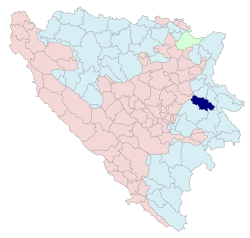 Location of Han Pijesak within Bosnia and Herzegovina | |
| Coordinates: 44°05′N 18°57′E / 44.083°N 18.950°E | |
| Country | Bosnia and Herzegovina |
| Government | |
| • Mayor | Milan Borovina (SDS) |
| Area | |
| • Total | 322,9 km2 (1,247 sq mi) |
| Population (2013 census) | |
| • Total | 3,844 |
| • Density | 11,9/km2 (310/sq mi) |
| Time zone | CET (UTC+1) |
| • Summer (DST) | CEST (UTC+2) |
| Area code(s) | 57 |
| Website | www.hanpijesak.net |
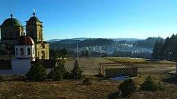
Han Pijesak (Serbian Cyrillic: Хан Пијесак) is a town and municipality in the Republika Srpska entity of Bosnia and Herzegovina.
Settlements
• Babine Gornje • Berkovina • Brložnik • Džimrije • Gođenje • Han Pijesak • Japaga • Jelovci • Kraljevo Polje • Kram • Krivače • Kusače • Malo Polje • Mrkalji • Nerići • Nevačka • Pjenovac • Plane • Podžeplje • Potkozlovača • Ravanjsko • Rečica • Rijeke • Rubinići • Stoborani • Žeravice • Kape
Demographics
1971
In the 1971 Yugoslav census, there were 7,804 total citizens
- 4,790 Serbs (61.37%)
- 2,921 Bosniaks (37.42%)
- 16 Croats (0.20%)
- 7 Yugoslavs (0.08%)
- 70 others (0.93%)
1991
In 1991, the population of Han Pijesak municipality was 6,346, including:
- 3,699 Serbs
- 2,544 Bosniaks
- 68 Yugoslavs
- 7 Croats
- 28 others
See also
External links
 |
Wikimedia Commons has media related to Han Pijesak. |









Coordinates: 44°05′N 18°57′E / 44.083°N 18.950°E
This article is issued from Wikipedia - version of the 4/18/2016. The text is available under the Creative Commons Attribution/Share Alike but additional terms may apply for the media files.