Haram Township, Bottineau County, North Dakota
| Haram Township | |
|---|---|
| Township | |
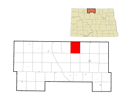 Location of Haram Township | |
| Coordinates: 48°56′22″N 100°39′00″W / 48.93944°N 100.65000°WCoordinates: 48°56′22″N 100°39′00″W / 48.93944°N 100.65000°W | |
| Country | United States |
| State | North Dakota |
| County | Bottineau |
| Organized | 1910 |
| Area[1] | |
| • Total | 43.59 sq mi (112.9 km2) |
| • Land | 43.53 sq mi (112.7 km2) |
| • Water | 0.06 sq mi (0.2 km2) |
| Elevation | 1,660 ft (506 m) |
| Population (2000)[1] | |
| • Total | 85 |
| • Density | 6.0/sq mi (2.3/km2) |
| Time zone | Central (CST) (UTC-6) |
| • Summer (DST) | CDT (UTC-5) |
| Area code(s) | 701 |
| FIPS code[2][3] | 38-35220 |
| U.S. Census GEOID[4] | 3800935220 |
| GNIS feature ID[5][6] | 1759277 |
Haram Township is a civil township in Bottineau County in the U.S. State of North Dakota. As of the 2000 census, its population was 85.[7]
History
Haram Township was organized in 1910 from Mountain View School Township in 1910.[8] The 1910 Census recorded a population of 424 in the township.
Early Norwegian settlers in the area named the township after Haram, Norway.[9]
Schools
- Mountain View School No. 2
- Mountain View School No. 3
Geography
Haram Township is located in survey townships 163N and 164N, Range 77W.[8] Township 164N, Range 77W is a fractional township containing less than the standard 36 sections of land, due its location along the U.S. border with Canada.
Natural features
- Boundary Creek
- Turtle Mountains
Cities and populated places
References
- 1 2 U.S. Census Bureau. Census 2000, Summary File 1. "GCT-PH1. Population, Housing Units, Area, and Density: 2000 - County -- Subdivision and Place". American FactFinder. <http://factfinder2.census.gov>. Retrieved 2008-01-31.
- ↑ "American FactFinder". United States Census Bureau. Retrieved 2008-01-31.
- ↑ "FIPS55 Data: North Dakota". FIPS55 Data. United States Geological Survey. February 23, 2006. Archived from the original (TXT) on June 18, 2006. External link in
|work=(help) - ↑ "County Subdivisions: North Dakota" (TXT). 2010 Census Gazetteer Files. United States Census Bureau. Retrieved January 22, 2013. External link in
|work=(help) - ↑ "US Board on Geographic Names". United States Geological Survey. 2007-10-25. Retrieved 2008-01-31.
- ↑ "Township of Haram". Geographic Names Information System. United States Geological Survey. Retrieved January 22, 2013.
- ↑ U.S. Census Bureau. Census 2000. "Census Demographic Profiles, Haram Township" (PDF). CenStats Databases. Retrieved 2009-01-31.
- 1 2 U.S. Census Bureau (1913). "Number of Inhabitants, North Dakota" (PDF). Thirteenth Census of the United States: 1910. Government Printing Office. p. 324. Retrieved 2008-07-20.
- ↑ Sherman, William C. (1983). Pairie Mosaic: An Ethnic Atlas of Rural North Dakota. Fargo, North Dakota: North Dakota Institute for Regional Studies. p. 71. ISBN 0-911042-27-X. OCLC 256228966.
This article is issued from Wikipedia - version of the 5/16/2016. The text is available under the Creative Commons Attribution/Share Alike but additional terms may apply for the media files.