Huantán District
| Huantán Wantan | |
|---|---|
| District | |
|
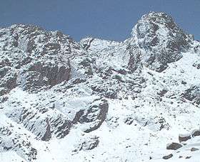
The mountain Wamp'una; entrance to Qaqa Mach'ay at left centre | |
| Country |
 Peru Peru |
| Region | Lima |
| Province | Yauyos |
| Founded | January 2, 1857 |
| Capital | Huantán |
| Government | |
| • Mayor | Erwin Edgardo Guerrero Chulluncuy |
| Area | |
| • Total | 516.35 km2 (199.36 sq mi) |
| Elevation | 3,290 m (10,790 ft) |
| Population (2005 census) | |
| • Total | 966 |
| • Density | 1.9/km2 (4.8/sq mi) |
| Time zone | PET (UTC-5) |
| UBIGEO | 151016 |
Huantán District is one of thirty-three districts of the province Yauyos in Peru.[1]
Geography
The Cordillera Central traverses the district. One of the highest peaks of the district is Upyanqa at approximately 5,300 m (17,400 ft). Other mountains are listed below:[2][3]
- Anta P'unqu
- Awki Sunqu
- Chaka Punta
- Chuntani
- Kaywa
- Llamayuq
- Maray
- Misitu
- Paquchi
- Puma Ranra
- P'allta Rumi
- P'ukru
- P'unqu
- P'unqu Punta
- Ruphasqa
- Sinchi Marka Punta
- Siq'i
- Suni Qaqa
- T'uru
- T'uruyuq
- Wampuru
- Wamp'una
- Wankarqucha
- Waylla
- Wayu Marka
- Yunka Warmi
See also
References
- ↑ (Spanish) Instituto Nacional de Estadística e Informática. Banco de Información Distrital. Retrieved April 11, 2008.
- ↑ escale.minedu.gob.pe - UGEL map of the Yauyos Province (Lima Region)
- ↑ Peru 1:100,000, Tupe 1745, Map prepared and published by the Defense Mapping Agency, Hydrographic/Topographic Center, Bethesda, MD
.svg.png)
Coordinates: 12°27′23″S 75°48′42″W / 12.4563°S 75.8116°W
This article is issued from Wikipedia - version of the 5/25/2016. The text is available under the Creative Commons Attribution/Share Alike but additional terms may apply for the media files.