Interstate 94 in North Dakota
| ||||
|---|---|---|---|---|
_map.svg.png) | ||||
| Route information | ||||
| Maintained by NDDOT | ||||
| Length: | 352.39 mi[1] (567.12 km) | |||
| Major junctions | ||||
| West end: |
 I‑94 at Montana state line I‑94 at Montana state line | |||
| East end: |
 I-94 / US 52 at Minnesota state line I-94 / US 52 at Minnesota state line | |||
| Highway system | ||||
| ||||

.svg.png)
.svg.png)
Interstate 94 runs east–west through the central portion of the U.S. state of North Dakota.
Route description
The route enters from Montana at Beach and immediately heads east, passing Dickinson, Bismarck, and Jamestown before entering Fargo and finally exiting the state.
The route passes to the south of Theodore Roosevelt National Park's southern unit. Access to the Northern unit is possible by taking US 85 north from Belfield.
The route crosses from Mountain Time Zone (UTC−7) into Central Time Zone (UTC−6) at the Stark/Morton County line and vice versa.
The route has a 75 miles per hour (121 km/h) posted speed limit between the Montana state line and Mandan near mile marker 152; a 60 miles per hour (97 km/h) posted speed limit between Mandan near mile marker 152 and Bismarck mile marker 160; a 75 miles per hour (121 km/h) posted speed limit between Bismarck at mile marker 160 and West Fargo near exit 346; a 65 miles per hour (105 km/h) posted speed limit in West Fargo between exit 346 and mile marker 347; and a 55 miles per hour (89 km/h) posted speed limit between West Fargo at mile marker 347 to the Minnesota state line.
Interstate 94 has two lanes in each direction through most of the state and 3 lanes in each direction in the Bismarck/Mandan area, from Exit 155 to Exit 156, and from the 45th Street exit (Exit 348) to the Red River (Minnesota state line) in Fargo.
Points of interest
The route enters at Beach and passes through the Badlands near Medora (near the Theodore Roosevelt National Park (South Unit)). A public rest area about seven miles (11 km) east of Medora provides an awe-inspiring view, especially at sunset, and an opportunity to hike through some of the scenery on the Painted Canyon Trail. Further east, I-94 provides access to the North Unit of Theodore Roosevelt National Park, then passes through the cities of Dickinson, Mandan, Bismarck, Jamestown, and Valley City on the way to West Fargo and Fargo, where it leaves the state and crosses into Minnesota. Throughout the state, the route generally travels relatively straight east and west following both the railroad route and the former route of US 10 (called "The Old Red Trail" or less commonly "The National Parks Trail"), where its western terminus is at Exit 343 in West Fargo.
The highway intersects with the Enchanted Highway 11 miles east of Dickinson at Exit 72. (The small green mile signs on the side of the road initialize at zero on the Montana border). At New Salem, it passes Salem Sue, a 38 foot high sculpture of a Holstein cow and is clearly visible from I-94 on the south side of the road. A drive up the road to Sue will take you to a vantage point where you can see a panoramic landscape for many miles. Between Mandan and Bismarck, I-94 crosses the Missouri River with a view of the Northern Pacific/BNSF Railroad Bridge on the South side of the road. At Steele, it passes the world's largest sculpture of a sand hill crane (named Sandy), which is 40 feet tall and visible from I-94 on the south side of the road, just to the east of exit 200. At Jamestown, it passes the world's largest sculpture of a buffalo (actually bison) named "Dakota Thunder", which is 28 feet tall and is visible from I-94 on the north side of the road.
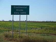
At approximately mile marker 275 on the westbound lanes between Jamestown and Valley City, the highway crosses the Laurentian Continental Divide. The rivers that are west of this divide flow South into the Atlantic Ocean at the Gulf of Mexico, while the rivers that are east of the divide flow North into the Arctic Ocean. The James River, that flows through Jamestown, feeds into the Atlantic Ocean, while the Sheyenne River, that flows through Valley City (36 miles east of Jamestown), feeds into the Arctic Ocean.
In Fargo, a well-known, but unnamed pedestrian bridge crosses over I-94. The bridge was built in 1976, in time for the United States' bicentennial. While providing a unique crossing for the surrounding neighborhoods, the bridge serves as a landmark for commuters and travelers. Westbound, it is one of the first North Dakota landmarks visible from the highway.[2]
History

Through the state, Interstate 94 follows the route once taken by U.S. Highway 10 west from Fargo. This route was originally called "The Old Red Trail". Prairie Public Television in North Dakota produced a documentary about US Highway 10 and the building of I-94 through the state.
Interstate 94 roughly follows the route of the former Northern Pacific Railway mainline (now a BNSF Railway route) across North Dakota. Many of the towns and cities that I-94 serves first grew as railroad towns in the nineteenth and early twentieth centuries.
The first section of I-94 completed with Interstate funds (under the Federal-Aid Highway Act of 1956) was a 12-mile (19 km) section between Jamestown and Valley City, North Dakota in 1958.
Spur routes
- I-194—a short spur route into Bismarck (Bismarck Expressway); unsigned
Exit list
| County | Location | mi[4] | km | Exit | Destinations | Notes |
|---|---|---|---|---|---|---|
| Golden Valley | | 0.000 | 0.000 | I‑94 west – Billings | Continuation into Montana | |
| Beach | 1.849 | 2.976 | 1 | .svg.png) ND 16 – Beach ND 16 – Beach | Rest area just south of exit | |
| | 7.368 | 11.858 | 7 | Home on the Range | ||
| | 10.478 | 16.863 | 10 | Camel Hump Lake, Sentinel Butte | ||
| | 18.452 | 29.696 | 18 | Buffalo Gap | ||
| Billings | | 23.001 | 37.017 | 23 | West River Road | Eastbound exit and westbound entrance |
| | 24.315 | 39.131 | 24 |  I-94 Bus. east – Theodore Roosevelt National Park, Medora I-94 Bus. east – Theodore Roosevelt National Park, Medora | ||
| | 27.243 | 43.843 | 27 | I-94 Bus. west – Theodore Roosevelt National Park, Medora | Westbound exit and eastbound entrance | |
| | 32.963 | 53.049 | 32 | Painted Canyon Visitor Center | ||
| | 36.861 | 59.322 | 36 | Fryburg | ||
| Stark | Belfield | 42.366 | 68.181 | 42 |  US 85 – Watford City, Belfield To North Unit of Theodore Roosevelt National Park US 85 – Watford City, Belfield To North Unit of Theodore Roosevelt National Park | Interchange with the Theodore Roosevelt Expressway |
| | 51.476 | 82.843 | 51 | South Heart | ||
| | 56.414 | 90.790 | 56 | (no name) | ||
| Dickinson | 59.485 | 95.732 | 59 | I-94 Bus. east – Dickinson | To Dickinson State University | |
| 61.476 | 98.936 | 61 | .svg.png) ND 22 – Killdeer, Dickinson ND 22 – Killdeer, Dickinson | |||
| 64.204 | 103.326 | 64 | I-94 Bus. west – Dickinson | |||
| | Former rest area[5] | |||||
| | 72.253 | 116.280 | 72 | Gladstone, Lefor | Enchanted Highway exit | |
| | 78.901 | 126.979 | 78 | Taylor | ||
| | 84.885 | 136.609 | 84 | .svg.png) ND 8 – Richardton, Mott ND 8 – Richardton, Mott | ||
| | 90.110 | 145.018 | 90 | (no name) | ||
| Morton | | 97.188 | 156.409 | 97 | Hebron | |
| | 102.914 | 165.624 | 102 | Glen Ullin, Hebron | Half-cloverleaf exit | |
| | 108.354 | 174.379 | 108 | Glen Ullin | ||
| | 110.367 | 177.618 | 110 | .svg.png) ND 49 – Beulah, Glen Ullin ND 49 – Beulah, Glen Ullin | ||
| | 113.389 | 182.482 | 113 | (no name) | ||
| | 117.197 | 188.610 | 117 | (no name) | ||
| | 120.204 | 193.450 | 120 | (no name) | ||
| | 123.200 | 198.271 | 123 | Almont | ||
| New Salem | 127.662 | 205.452 | 127 | .svg.png) ND 31 north – Hazen, New Salem ND 31 north – Hazen, New Salem | ||
| | 134.115 | 215.837 | 134 | Sweet Briar Lake, Judson | Scenic View just east of exit on westbound side | |
| | 140.118 | 225.498 | 140 | Crown Butte Dam | ||
| | 147.183 | 236.868 | 147 | .svg.png) .svg.png) ND 25 / I-94 Bus. east to ND 6 – Center, Mandan ND 25 / I-94 Bus. east to ND 6 – Center, Mandan | ||
| Mandan | 152.329 | 245.150 | 152 | Sunset Drive – Mandan | Scenic View just west of exit on eastbound side | |
| 153.988 | 247.820 | 153 | .svg.png) ND 1806 (Mandan Avenue) ND 1806 (Mandan Avenue) | |||
| 155.026 | 249.490 | 155 | To I-94 Bus. / ND 6 – Mandan City Center | Westbound exit and eastbound entrance | ||
| 156.069 | 251.169 | 156 | To I-94 Bus. / Bismarck Expressway (I-194) – Bismarck City Center, West Bismarck, East Mandan | |||
| Missouri River | Grant Marsh Bridge | |||||
| Burleigh | Bismarck | 157.344 | 253.221 | 157 | Divide Avenue | Modified half-cloverleaf interchange |
| 159.419 | 256.560 | 159 |  US 83 north (ND 1804) – Minot, Bismarck US 83 north (ND 1804) – Minot, Bismarck | West end of US 83 overlap, North Dakota State Capitol | ||
| 161.439 | 259.811 | 161 | Bismarck Expressway (I-94 Bus. west) – Lincoln | |||
| | 170.519 | 274.424 | 170 | Menoken | ||
| | 176.501 | 284.051 | 176 | McKenzie | ||
| | 182.488 | 293.686 | 182 | .svg.png) US 83 south / ND 14 north – Wing, Sterling US 83 south / ND 14 north – Wing, Sterling | East end of US 83 overlap | |
| | 190.110 | 305.952 | 190 | Driscoll | ||
| Kidder | | 195.090 | 313.967 | 195 | (no name) | |
| Steele | 200.760 | 323.092 | 200 | .svg.png) ND 3 north – Tuttle, Steele ND 3 north – Tuttle, Steele | West end of ND 3 overlap | |
| | 205.071 | 330.030 | 205 | Robinson | ||
| Dawson | 208.702 | 335.873 | 208 | ND 3 south – Dawson | East end of ND 3 overlap | |
| Tappen | 214.126 | 344.602 | 214 | Tappen | ||
| | 217.145 | 349.461 | 217 | Pettibone | ||
| | 221.733 | 356.845 | 221 | Crystal Springs | ||
| Stutsman | | 228.321 | 367.447 | 228 | .svg.png) ND 30 south – Streeter ND 30 south – Streeter | |
| | 230.288 | 370.613 | 230 | Medina, Woodworth | ||
| | 233.343 | 375.529 | 233 | (no name) | ||
| Cleveland | 238.793 | 384.300 | 238 | Cleveland, Gackle | ||
| | 242.672 | 390.543 | 242 | Windsor | ||
| | 245.191 | 394.597 | 245 | (no name) | ||
| | 248.991 | 400.712 | 248 | (no name) | ||
| | 251.686 | 405.049 | 251 | Eldridge | ||
| | 256.224 | 412.353 | 256 |    US 52 Truck west / US 281 Truck north US 52 Truck west / US 281 Truck north | West end of US 52 Truck/US 281 Truck overlap | |
| Jamestown | 257.002 | 413.605 | 257 | I-94 Bus. east – Jamestown | Eastbound exit and westbound entrance; left exit | |
| 258.055 | 415.299 | 258 | US 52 west / US 281 – Jamestown | East end of US 52/US 281 Truck Bypass overlap; west end of US 52 overlap | ||
| 260.125 | 418.631 | 260 | I-94 Bus. west – Jamestown | |||
| | 262.361 | 422.229 | 262 | Jamestown Regional Airport, Bloom | ||
| | 269.355 | 433.485 | 269 | Spiritwood | ||
| Barnes | | 272.369 | 438.335 | 272 | (no name) | |
| | 276.385 | 444.799 | 276 | Eckelson, Marion | ||
| | 281.640 | 453.256 | 281 | Sanborn | ||
| | 283.139 | 455.668 | 283 | .svg.png) ND 1 north – Rogers ND 1 north – Rogers | West end of ND 1 overlap | |
| | 288.636 | 464.515 | 288 | ND 1 south – Verona, Oakes | East end of ND 1 overlap | |
| Valley City | 290.803 | 468.002 | 290 | I-94 Bus. east – Valley City | ||
| 292.072 | 470.044 | 292 | Valley City | |||
| 294.283 | 473.603 | 294 | I-94 Bus. west – Valley City | |||
| | 296.741 | 477.558 | 296 | (no name) | ||
| | 298.746 | 480.785 | 298 | (no name) | ||
| Oriska | 302.712 | 487.168 | 302 | .svg.png) ND 32 – Oriska, Fingal ND 32 – Oriska, Fingal | ||
| Tower City | 307.679 | 495.161 | 307 | Tower City | ||
| Cass | | 310.456 | 499.631 | 310 | (no name) | |
| | 314.863 | 506.723 | 314 | .svg.png) ND 38 – Buffalo, Alice ND 38 – Buffalo, Alice | ||
| | 317.846 | 511.524 | 317 | Ayr | ||
| | 320.837 | 516.337 | 320 | Embden | ||
| | 322.827 | 519.540 | 322 | Absaraka | ||
| | 324.821 | 522.749 | 324 | Wheatland, Chaffee | ||
| | 328.710 | 529.007 | 328 | Lynchburg | ||
| Casselton | 331.226 | 533.057 | 331 | .svg.png) ND 18 – Casselton, Leonard ND 18 – Casselton, Leonard | ||
| Mapleton | 338.737 | 545.144 | 338 | Mapleton | ||
| | 340.717 | 548.331 | 340 | Kindred | ||
| | 342.721 | 551.556 | 342 | (no name) | ||
| West Fargo | 343.803 | 553.297 | 343 |  US 10 / I-94 Bus. east – West Fargo, Fargo US 10 / I-94 Bus. east – West Fargo, Fargo | ||
| 346.442 | 557.544 | 346 | Sheyenne Street | Signed as exits 346A (south) and 346B (north) westbound | ||
| 347.786 | 559.707 | 347 | Veterans Boulevard, 9th Street East | Signed as 9th Street East north of I-94 and Veterans Boulevard south of I-94 | ||
| Fargo | 348.481 | 560.826 | 348 | 45th Street | ||
| 349.584 | 562.601 | 349 |   I-29 / US 81 – Grand Forks, Sioux Falls I-29 / US 81 – Grand Forks, Sioux Falls | Signed as exits 349A (south) and 349B (north); I-29 exits 63A-B | ||
| 350.586 | 564.213 | 350 | 25th Street | |||
| 351.590 | 565.829 | 351 |  US 81 Bus. (University Drive) – Downtown Fargo US 81 Bus. (University Drive) – Downtown Fargo | |||
| 352.39 | 567.12 | I-94 east / US 52 east | Continuation into Minnesota | |||
1.000 mi = 1.609 km; 1.000 km = 0.621 mi
| ||||||
References
 |
Wikimedia Commons has media related to Interstate 94 in North Dakota. |
- ↑ "Route Log and Finder List — Interstate System: Table 1". FHWA. Retrieved 2007-09-26.
- ↑ Kerzman, Kris. "Throwback Thursday: A brief history of the Interstate 94 walking bridge". INFORUM. The Forum of Fargo-Moorhead. Retrieved 14 July 2016.
- ↑ Galadriel Findlay Watson (2001). North Dakota. Weigl Publishers Inc. p. 5. ISBN 1-930954-53-0.
- ↑ "Appendix III-09 B: Interchange Numbering on I-94" (PDF). North Dakota Department of Transportation. Retrieved 2008-06-22.
- ↑ Google (September 3, 2013). "Former Rest Area" (Map). Google Maps. Google. Retrieved September 3, 2013.
External links
| Interstate 94 | ||
|---|---|---|
| Previous state: Montana |
North Dakota | Next state: Minnesota |