McKenzie, North Dakota
| McKenzie, North Dakota | |
|---|---|
| Unincorporated community | |
  McKenzie, North Dakota Location within the state of North Dakota | |
| Coordinates: 46°49′20″N 100°24′55″W / 46.82222°N 100.41528°WCoordinates: 46°49′20″N 100°24′55″W / 46.82222°N 100.41528°W | |
| Country | United States |
| State | North Dakota |
| County | Burleigh |
| Area | |
| • Total | 35.9 sq mi (93.1 km2) |
| • Land | 35.9 sq mi (93.0 km2) |
| • Water | 0.08 sq mi (0.2 km2) |
| Elevation | 1,749 ft (533 m) |
| Population (2000) | |
| • Total | 83 |
| • Density | 2.3/sq mi (0.89/km2) |
| Time zone | Central (CST) (UTC-6) |
| • Summer (DST) | CDT (UTC-5) |
| ZIP code | 58572 |
| Area code(s) | 701 |
| FIPS code | 38-49380[1] |
| GNIS feature ID | 1759339[2] |
McKenzie is an unincorporated community in Burleigh County, North Dakota, United States. It lies about 20 miles east of Bismarck along I-94/US 83. McKenzie's ZIP code is 58572.
A post office called McKenzie was established in 1887, and remained in operation until 1965.[3] The community was named after early North Dakota politician Alexander McKenzie.[4]
References
- ↑ "American FactFinder". United States Census Bureau. Archived from the original on September 11, 2013. Retrieved 2008-01-31.
- ↑ "US Board on Geographic Names". United States Geological Survey. 2007-10-25. Retrieved 2008-01-31.
- ↑ "Burleigh County". Jim Forte Postal History. Retrieved 23 October 2015.
- ↑ Federal Writers' Project (1938). North Dakota, a Guide to the Northern Prairie State,. WPA. p. 288. ISBN 978-1-62376-033-5.
Municipalities and communities of Burleigh County, North Dakota, United States | ||
|---|---|---|
| Cities | 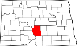 | |
| Townships |
| |
| CDPs | ||
| Unorganized territories |
| |
| Unincorporated communities | ||
| Footnotes | ‡This populated place also has portions in an adjacent county or counties | |
| Counties |  | |
|---|---|---|
| Core cities | ||
| Surrounding areas |
| |
This article is issued from Wikipedia - version of the 10/31/2016. The text is available under the Creative Commons Attribution/Share Alike but additional terms may apply for the media files.