Ichuña District
| Ichuña | |
|---|---|
| District | |
|
Ichuña | |
| Country |
 Peru Peru |
| Region | Moquegua |
| Province | General Sánchez Cerro |
| Founded | January 2, 1857 |
| Capital | Ichuña |
| Government | |
| • Mayor | Melecio Eleusipo Flores Ventura |
| Area | |
| • Total | 1,017.74 km2 (392.95 sq mi) |
| Elevation | 3,756 m (12,323 ft) |
| Population (2005 census) | |
| • Total | 3,782 |
| • Density | 3.7/km2 (9.6/sq mi) |
| Time zone | PET (UTC-5) |
| UBIGEO | 180204 |
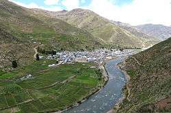
Ichuña District is one of eleven districts of the province General Sánchez Cerro in Peru.[1]
Ethnic groups
The people in the district are mainly indigenous citizens of Quechua descent. Quechua is the language which the majority of the population (79.61%) learnt to speak in childhood, 12.86% of the residents started speaking using the Spanish language (2007 Peru Census).[2]
Geography
Some of the highest peaks of the district are listed below:[3]
- Allqamarini
- Chuqipata
- Churi Wiqu
- Ch'iyar Jaqhi
- Ch'unch'uni
- Janq'u Saxa
- Jaqhi Jaqhini
- Jat'u K'achi
- Jichu Qullu
- Kuntur Sayana
- Larama Quta
- Llallawa
- Machuyuq
- Millu
- Pachakutiq
- Pukara
- Pura Purani
- Qañiwa
- Qayqu
- Q'ulini
- Rukutuni
- Saya Muqu
- Taruj Sallani
- T'ula Qullu
- Uqi Muqu
- Uturunqani (Ichuña)
- Uturunqani (Moquegua-Puno)
- Wallqani
- Wankarani
- Wari Pukara
- Wayllani
- Wila Qullu
- Wila Sirka
See also
References
- ↑ (Spanish) Instituto Nacional de Estadística e Informática. Banco de Información Distrital. Retrieved April 11, 2008.
- ↑ inei.gob.pe INEI, Peru, Censos Nacionales 2007, Frequencias: Preguntas de Población: Idioma o lengua con el que aprendió hablar (in Spanish)
- ↑ escale.minedu.gob.pe - UGEL map of the General Sánchez Cerro Province (Tacna Region) and the Maariscal Nieto Province (Moquegua)
| |
|---|---|
| General Sánchez Cerro | |
| Ilo | |
| Mariscal Nieto | |
.svg.png)
Coordinates: 16°08′26″S 70°32′09″W / 16.1406°S 70.5357°W
This article is issued from Wikipedia - version of the 3/10/2016. The text is available under the Creative Commons Attribution/Share Alike but additional terms may apply for the media files.