Istaravshan District
| Istaravshan District | |
|---|---|
| District | |
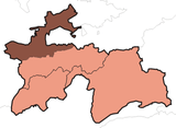
 Location of Istaravshan District in Tajikistan | |
| Country |
 Tajikistan Tajikistan |
| Province | Sughd |
| Capital | Istaravshan |
| Time zone | TJT (UTC+5) |
Istaravshan District or Nohiya-i Istaravshan (Tajik: Ноҳияи Истаравшан/Persian: ناحیۀ استروشن), formerly Uroteppa (or Ura-Tyube) District (Tajik: Уротеппа, Russian: Ура-Тюбе), is a district in the central part of Sughd province, Tajikistan, between the border with Uzbekistan to the west and Ghonchi district to the east.[1] Its capital is Istaravshan (called Ura-Tyube until 2000).
Administrative divisions
The district is divided administratively into jamoats. They are as follows (and population).[2]
| Jamoats of Istaravshan District | |||||||||||
| Jamoat | Population | ||||||||||
|---|---|---|---|---|---|---|---|---|---|---|---|
| Nijoni | 7747 | ||||||||||
| Frunze | 11058 | ||||||||||
| Kommunizm | 22190 | ||||||||||
| Guli surkh | 28799 | ||||||||||
| Poshkent | 13292 | ||||||||||
| Pravda | 11652 | ||||||||||
| Javkandak | 7535 | ||||||||||
| Leninobod | 11468 | ||||||||||
| Qalaibaland | 6759 | ||||||||||
| Nofaroj | 7343 | ||||||||||
References
- ↑ Republic of Tajikistan, map showing administrative division as of January 1, 2004, "Tojjikoinot" Cartographic Press, Dushanbe
- ↑ "List of Jamoats". UN Coordination, Tajikistan. Retrieved April 4, 2009.

This article is issued from Wikipedia - version of the 10/2/2013. The text is available under the Creative Commons Attribution/Share Alike but additional terms may apply for the media files.