Jenkinsville, South Carolina
| Jenkinsville, South Carolina | |
|---|---|
| Town | |
  Jenkinsville  Jenkinsville | |
| Coordinates: 34°16′4″N 81°17′16″W / 34.26778°N 81.28778°WCoordinates: 34°16′4″N 81°17′16″W / 34.26778°N 81.28778°W | |
| Country | United States |
| State | South Carolina |
| County | Fairfield |
| Area | |
| • Total | 0.09 sq mi (0.23 km2) |
| • Land | 0.09 sq mi (0.23 km2) |
| • Water | 0.0 sq mi (0.0 km2) |
| Elevation | 450 ft (140 m) |
| Population (2010) | |
| • Total | 46 |
| • Density | 516/sq mi (199.1/km2) |
| Time zone | EST (UTC-5) |
| • Summer (DST) | EDT (UTC-4) |
| ZIP code | 29065 |
| Area code(s) | 803 |
| FIPS code | 45-36655[1] |
| GNIS feature ID | 1246161[2] |
Jenkinsville is an incorporated town in western Fairfield County, South Carolina, United States, between the Broad and the Little rivers. It is located east of Monticello Reservoir[3] and is near the Virgil C. Summer Nuclear Generating Station. Also in the area is the Kincaid-Anderson House[4] and quarry. The town is South Carolina's newest, incorporating in 2008.[5] Jenkinsville's population at the 2010 census was 46, making it South Carolina's smallest town.[1]
In addition to the Kincaid-Anderson House, the Ebenezer Associate Reformed Presbyterian Church, Dr. John Glenn House, High Point, Little River Baptist Church, and Mayfair are listed on the National Register of Historic Places.[6]
Demographics
| Historical population | |||
|---|---|---|---|
| Census | Pop. | %± | |
| 2010 | 46 | — | |
| Est. 2015 | 44 | [7] | −4.3% |
As of the 2010 United States Census, there were 46 people residing in the town. 100.0% were African American.[9]
References
- 1 2 "Geographic Identifiers: 2010 Demographic Profile Data (G001): Jenkinsville town, South Carolina". U.S. Census Bureau, American Factfinder. Retrieved August 12, 2016.
- ↑ U.S. Geological Survey Geographic Names Information System: Jenkinsville, South Carolina
- ↑ http://www.discoversouthcarolina.com/product.aspx?productID=25575
- ↑ http://www.nationalregister.sc.gov/fairfield/S10817720019/index.htm
- ↑ http://www.masc.sc/municipalities/Pages/default.aspx
- ↑ National Park Service (2010-07-09). "National Register Information System". National Register of Historic Places. National Park Service.
- ↑ "Annual Estimates of the Resident Population for Incorporated Places: April 1, 2010 to July 1, 2015". Retrieved July 2, 2016.
- ↑ "Census of Population and Housing". Census.gov. Retrieved June 4, 2015.
- ↑ "Profile of General Population and Housing Characteristics: 2010 Census Summary File 1 (DP-1): Jenkinsville town, South Carolina". U.S. Census Bureau, American Factfinder. Retrieved August 12, 2016.
Municipalities and communities of Fairfield County, South Carolina, United States | ||
|---|---|---|
| Towns | 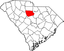 | |
| CDP | ||
| Unincorporated communities | ||
| Footnotes | ‡This populated place also has portions in an adjacent county or counties | |