Kasa-Vubu, Kinshasa
| Kasa-Vubu Commune de Kasa-Vubu | |
|---|---|
| Commune | |
 Kasa-Vubu on a map of Kinshasa communes | |
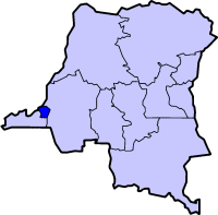 Kinshasa city-province on a map of the DRC | |
| Coordinates: 04°20′33″S 015°18′19″E / 4.34250°S 15.30528°ECoordinates: 04°20′33″S 015°18′19″E / 4.34250°S 15.30528°E[1] | |
| Country | Democratic Republic of the Congo |
| Province | Kinshasa |
| District | Funa |
| Area | |
| • Total | 5.05 km2 (1.95 sq mi) |
| Population (2004 est.) | |
| • Total | 157,320 |
| • Density | 31,000/km2 (81,000/sq mi) |
Kasa-Vubu is a municipality (commune) in the Funa district of Kinshasa, the capital city of the Democratic Republic of the Congo.[2]
Along with Kalamu, it forms the historical African heart of Kinshasa. Formerly known as Dendale, the town's name derives from the first president of the Congo after independence, Joseph Kasa-Vubu, who was elected mayor of the commune in 1957.
Demographics
| Year | 1967 | 1970 | 1984 | 2003 | 2004 |
|---|---|---|---|---|---|
| Population | 56,540 | 67,525 | 74,888 | 152,141 | 157,320 |
References
- ↑ "Kasa Vubu, Kinshasa, Democratic Republic of the Congo". Google Maps. Retrieved 20 August 2011.
- ↑ "Géographie de Kinshasa (Geography of Kinshasa)" (in French). Ville de Kinshasa (City of Kinshasa). Retrieved 20 August 2011.
See also
 |
Wikimedia Commons has media related to Kasa-Vubu (Kinshasa). |

This article is issued from Wikipedia - version of the 11/9/2016. The text is available under the Creative Commons Attribution/Share Alike but additional terms may apply for the media files.