Kerrtown, Pennsylvania
| Kerrtown, Pennsylvania | |
|---|---|
| Census-designated place | |
  Kerrtown | |
| Coordinates: 41°37′45″N 80°9′47″W / 41.62917°N 80.16306°WCoordinates: 41°37′45″N 80°9′47″W / 41.62917°N 80.16306°W | |
| Country | United States |
| State | Pennsylvania |
| County | Crawford |
| Township | Vernon |
| Area | |
| • Total | 0.8 sq mi (2.2 km2) |
| • Land | 0.8 sq mi (2.2 km2) |
| • Water | 0.0 sq mi (0.0 km2) |
| Elevation | 1,100 ft (300 m) |
| Population (2010) | |
| • Total | 305 |
| • Density | 361/sq mi (139.2/km2) |
| Time zone | Eastern (EST) (UTC-5) |
| • Summer (DST) | EDT (UTC-4) |
| ZIP code | 16335 |
| FIPS code | 42-39504 |
| GNIS feature ID | 2633702 |
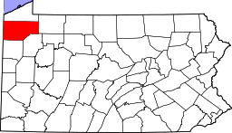
Kerrtown is a census-designated place[1] located in Vernon Township, Crawford County, in the state of Pennsylvania. Its location is at the intersection of U.S. Routes 6/19/322 and Pennsylvania Route 102, just west of the city of Meadville. As of the 2010 census the population of Kerrtown was 305.[2]
References
- ↑ http://www.census.gov/2010census/
- ↑ "Geographic Identifiers: 2010 Census Summary File 1 (G001): Kerrtown CDP, Pennsylvania". U.S. Census Bureau, American Factfinder. Retrieved June 17, 2015.
External links
This article is issued from Wikipedia - version of the 9/4/2016. The text is available under the Creative Commons Attribution/Share Alike but additional terms may apply for the media files.