Mississippi Highway 30
| ||||
|---|---|---|---|---|
| Route information | ||||
| Maintained by MDOT | ||||
| Length: | 78.968 mi[1] (127.087 km) | |||
| Major junctions | ||||
| West end: |
 MS 7 in Oxford MS 7 in Oxford | |||
  I-22 / US 78 in New Albany I-22 / US 78 in New Albany US 45 from Wheeler to Booneville US 45 from Wheeler to Booneville | ||||
| East end: | Natchez Trace Parkway near Tishomingo | |||
| Highway system | ||||
| ||||


Mississippi Highway 30 is an east–west corridor that runs from Oxford, Mississippi, at the western terminus to the Natchez Trace Parkway at the eastern terminus.
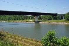
MS Highway 30 bridge passing over the Tennessee-Tombigbee Waterway near Paden
Major intersections
| County | Location | mi | km | Destinations | Notes |
|---|---|---|---|---|---|
| Lafayette | Oxford |   MS 7 to I-55 / MS 6 – Holly Springs, Water Valley, Batesville MS 7 to I-55 / MS 6 – Holly Springs, Water Valley, Batesville | Interchange | ||
| Union | |  MS 355 south – Etta MS 355 south – Etta | |||
| |  MS 349 north – Macedonia, Cornersville, Potts Camp MS 349 north – Macedonia, Cornersville, Potts Camp | ||||
| New Albany | I-22 west / US 78 west – Memphis, Museum | Western end of I-22 / US 78 overlap; MS 30 west follows exit 61 | |||
| Downtown New Albany | I-22 exit 63 | ||||
 I-22 east / US 78 east / MS 15 south – Tupelo, Pontotoc I-22 east / US 78 east / MS 15 south – Tupelo, Pontotoc | Eastern end of I-22 / US 78 overlap; western end of MS 15 overlap; MS 30 east follows exit 64 | ||||
 MS 178 – Downtown New Albany MS 178 – Downtown New Albany | |||||
 MS 348 east – Center, Ellistown MS 348 east – Center, Ellistown | |||||
| MS 15 north – Ripley, Union County Museum, Northeast Mississippi Community College | Eastern end of MS 15 overlap | ||||
| Pleasant Ridge |  MS 370 west MS 370 west | ||||
| Graham |  MS 9 south to MS 370 – Sherman, Alpine MS 9 south to MS 370 – Sherman, Alpine | ||||
| Prentiss | Frankstown | US 45 south – Tupelo | Interchange; western end of US 45 overlap | ||
| Booneville | US 45 north – Corinth | Interchange; eastern end of US 45 overlap | |||
 MS 145 – Booneville MS 145 – Booneville | Interchange | ||||
| |  MS 4 – East Booneville MS 4 – East Booneville | Interchange | |||
| |  MS 364 east MS 364 east | ||||
| Burton |  MS 365 north – Cairo, Burnsville MS 365 north – Cairo, Burnsville | ||||
| Tishomingo | |  MS 25 – Iuka, Tishomingo, Tishomingo State Park MS 25 – Iuka, Tishomingo, Tishomingo State Park | |||
| Mingo |  Natchez Trace Parkway Natchez Trace Parkway | Interchange | |||
| 1.000 mi = 1.609 km; 1.000 km = 0.621 mi | |||||
See also
References
- ↑ "Mississippi Public Roads Selected Statistics" (PDF). Mississippi Department of Transportation. 2008. Retrieved 2010-06-03.
This article is issued from Wikipedia - version of the 1/16/2016. The text is available under the Creative Commons Attribution/Share Alike but additional terms may apply for the media files.