Majagual, Sucre
| Majagual | ||
|---|---|---|
| Municipality and town | ||
| ||
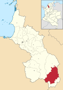 Location of the municipality and town of Majagual in the Sucre Department of Colombia. | ||
| Country |
 Colombia Colombia | |
| Department | Sucre Department | |
| Area | ||
| • Municipality and town | 826 km2 (319 sq mi) | |
| Elevation | 28 m (92 ft) | |
| Population (2015) | ||
| • Municipality and town | 33,258 | |
| • Density | 40/km2 (100/sq mi) | |
| • Urban | 10,883 | |
| Time zone | Colombia Standard Time (UTC-5) | |
.svg.png)
Majagual (Spanish pronunciation: [maxaˈɣwal]) is a town and municipality located in the Sucre Department, northern Colombia.
References
- (Spanish) Gobernacion de Sucre - Majagual
Municipalities in Sucre Department | ||
|---|---|---|
.svg.png) | ||
Coordinates: 8°30′N 74°40′W / 8.500°N 74.667°W
This article is issued from Wikipedia - version of the 8/31/2016. The text is available under the Creative Commons Attribution/Share Alike but additional terms may apply for the media files.