Matuguinao, Samar
| Matuguinao | |
|---|---|
| Municipality | |
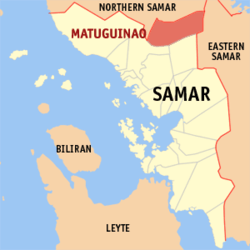 Map of Samar with Matuguinao highlighted | |
.svg.png)  Matuguinao Location within the Philippines | |
| Coordinates: 12°09′N 124°53′E / 12.150°N 124.883°ECoordinates: 12°09′N 124°53′E / 12.150°N 124.883°E | |
| Country | Philippines |
| Region | Eastern Visayas (Region VIII) |
| Province | Samar |
| Congr. district | 1st district of Samar |
| Barangays | 20 |
| Government[1] | |
| • Mayor | Melissa A. Dela Cruz |
| • Vice-Mayor | Carmel Dela Cruz |
| • Council |
Councilors
|
| Area[2] | |
| • Total | 172.51 km2 (66.61 sq mi) |
| Population (2010)[3] | |
| • Total | 6,746 |
| • Density | 39/km2 (100/sq mi) |
| Time zone | PST (UTC+8) |
| ZIP code | 6708 |
| Dialing code | 55 |
Matuguinao is a fifth class municipality in the province of Samar, Philippines. According to the 2010 census, it has a population of 6,746 people.[3] Matuguinao were named as a municipal district of Gandara in the year 1948 to 1960 and were converted into a municipality in 1965.
History
Matuguinao or Matugnaw is a word that literally means cold.
Baraŋgays
Matuguinao is politically subdivided into 20 barangays.[2]
- Angyap
- Barruz (Barangay No. 1)
- Camonoan
- Carolina
- Deit
- Del Rosario
- Libertad
- Ligaya
- Mabuligon (Pob.)
- Maduroto (Pob.)
- Mahanud
- Mahayag
- Nagpapacao
- Rizal
- Salvacion
- San Isidro
- Santa Cruz
- Bag-otan
- Inubod
- San Roque (Mabuhay)
Demographics
| Population census of Matuguinao | ||
|---|---|---|
| Year | Pop. | ±% p.a. |
| 1990 | 3,819 | — |
| 1995 | 5,205 | +5.97% |
| 2000 | 5,361 | +0.64% |
| 2007 | 6,589 | +2.89% |
| 2010 | 6,746 | +0.86% |
| Source: National Statistics Office[3][4] | ||
Water and Sanitation
Water is abundant here in this town, it has cold and hot water source.
Solid Waste Management
Garbage are being collected here manually by a karitilya, it is dumped on its garbage dumpsite right side along provincial road going to Matuguinao and after Barruz.
References
- ↑ "Municipalities". Quezon City, Philippines: Department of the Interior and Local Government. Retrieved 14 May 2013.
- 1 2 "Province: Samar (Western Samar)". PSGC Interactive. Makati City, Philippines: National Statistical Coordination Board. Retrieved 14 May 2013.
- 1 2 3 "Total Population by Province, City, Municipality and Barangay: as of May 1, 2010" (PDF). 2010 Census of Population and Housing. National Statistics Office. Retrieved 14 May 2013.
- ↑ "Province of Western Samar". Municipality Population Data. LWUA Research Division. Retrieved 21 August 2013.
External links
- Philippine Standard Geographic Code
- Philippine Census Information
- Local Governance Performance Management System
 |
Silvino Lobos, Northern Samar | Las Navas, Northern Samar | | |
 |
Jipapad, Eastern Samar | |||
| ||||
 | ||||
| Gandara | San Jose de Buan | Maslog, Eastern Samar |


 Province of Samar Province of Samar | |
|---|---|
Catbalogan (capital) | |
| Municipalities | |
| Component cities | |
This article is issued from Wikipedia - version of the 7/12/2016. The text is available under the Creative Commons Attribution/Share Alike but additional terms may apply for the media files.