Montana Highway 200
| ||||
|---|---|---|---|---|
 | ||||
| Route information | ||||
| Maintained by MDT | ||||
| Length: | 706.624 mi[1] (1,137.201 km) | |||
| Major junctions | ||||
| West end: |
 SH-200 northwest of Heron SH-200 northwest of Heron | |||
 US 93 from Ravalli to Missoula US 93 from Ravalli to Missoula I‑90 from Wye to Bonner I‑90 from Wye to Bonner US 12 from Missoula to Bonner US 12 from Missoula to Bonner US 287 near Milford Colony US 287 near Milford Colony US 89 from Vaughn to Armington US 89 from Vaughn to Armington I‑15 near Great Falls I‑15 near Great Falls US 87 from Great Falls to Grass Range US 87 from Great Falls to Grass Range US 191 from near Hobson to Lewistown US 191 from near Hobson to Lewistown | ||||
| East end: |
.svg.png) ND 200 at Fairview ND 200 at Fairview | |||
| Location | ||||
| Counties: | Richland, Dawson, McCone, Garfield, Petroleum, Fergus, Judith Basin, Cascade, Lewis and Clark, Powell, Missoula, Lake, Sanders | |||
| Highway system | ||||
| ||||
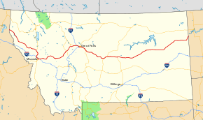
Highway 200 (MT 200) in the U.S. state of Montana is a route running east-west covering the entire state of Montana. From the starting point at ID 200, near Heron, Montana the highway runs east to ND 200 near Fairview, Montana. It is part of a chain of state highways numbered 200 which extend from Idaho across Montana, North Dakota and Minnesota. Montana Highway 200 is also the longest route signed as a state highway in the United States.
Highway 200 helps to connect many small towns located in central Montana and the vast plains area of eastern Montana, to larger western Montana cities such as Great Falls and Missoula.
The highway runs parallel to the Blackfoot River from McNamara to Milltown. The highway is subject to hazardous driving conditions in the winter, particularly due to black ice. The road crosses Rogers Pass on the continental divide on its way west to Missoula.
At its western end, west of Missoula, Highway 200 follows the Clark Fork River eastward at the feet of the Cabinet Mountains until it meets the Flathead River at MT 135. It then follows the Flathead River east to Dixon where the Flathead River turns north. Highway 200 continues east following the Jocko River until the intersection of Highway 200 and US 93 at Ravalli. The highway then bends south to join I-90 east into Missoula.
Major intersections
| County | Location | mi | km | Destinations | Notes |
|---|---|---|---|---|---|
| Sanders | | 0.000 | 0.000 | SH-200 west – Sandpoint | Continuation into Idaho |
| | 10.418 | 16.766 |   MT 56 north to US 2 – Troy MT 56 north to US 2 – Troy | ||
| |  S-471 west S-471 west | ||||
| |  S-556 north (Thompson River Road) S-556 north (Thompson River Road) | ||||
| | 76.706 | 123.446 |  MT 28 east – Hot Springs, Kalispell, Glacier Park MT 28 east – Hot Springs, Kalispell, Glacier Park | ||
| | 85.030 | 136.843 |  MT 135 south to I‑90 – St. Regis MT 135 south to I‑90 – St. Regis | ||
| |  S-382 north – Hot Springs S-382 north – Hot Springs | ||||
| |  S-212 north – National Bison Range, Moiese, Charlo S-212 north – National Bison Range, Moiese, Charlo | ||||
| Lake | Ravalli | 115.803 | 186.367 | US 93 north – Kalispell | West end of US 93 overlap |
| |  S-559 east (Jocko Road) S-559 east (Jocko Road) | ||||
| Missoula | |  S-574 west (Waldo Road / Frontage Road) – Frenchtown S-574 west (Waldo Road / Frontage Road) – Frenchtown | |||
| Wye | 143.004 | 230.143 | I‑90 west – Coeur d'Alene | West end of I-90 overlap; MT 200 west follows exit 96 | |
| | 146.612 | 235.949 | Airway Boulevard | I-90 exit 99 | |
| Missoula | 148.388 | 238.807 |  I‑90 Bus. east / US 93 south (Reserve Street) – Hamilton I‑90 Bus. east / US 93 south (Reserve Street) – Hamilton | East end of US 93 overlap; I-90 exit 101 | |
| 151.451 | 243.737 | Orange Street | I-90 exit 104 | ||
| 152.315 | 245.127 | I‑90 Bus. west / US 12 west (Van Buren Street) | West end of US 12 overlap; I-90 exit 105 | ||
| East Missoula | 153.940 | 247.742 | East Missoula | I-90 exit 107 | |
| West Riverside | 156.885 | 252.482 | I‑90 east / US 12 east – Butte | East end of I-90 / US 12 overlap; MT 200 east follows exit 109 | |
| Bonner |  S-210 east S-210 east | ||||
| Clearwater Junction | 189.465 | 304.914 |  MT 83 north – Seeley Lake, Kalispell, Glacier National Park MT 83 north – Seeley Lake, Kalispell, Glacier National Park | ||
| Powell | | 213.308 | 343.286 |  MT 141 south – Avon, Helmville MT 141 south – Avon, Helmville | |
| Lewis and Clark | |  S-279 south – Helena S-279 south – Helena | |||
| Rogers Pass | 248 | 399 | Continental Divide (elevation 5,610 feet (1,710 m)) | ||
| |  S-434 south – Wolf Creek, Bean Lake S-434 south – Wolf Creek, Bean Lake | ||||
| Bowman's Corner | 266.655 | 429.140 | US 287 – Augusta, Wolf Creek | ||
| Cascade | Simms |  MT 21 west – Augusta MT 21 west – Augusta | |||
 S-565 north S-565 north | |||||
| | 297.069 | 478.086 | US 89 north – Fairfield, Choteau, Glacier National Park | West end of US 89 overlap | |
| | 305.044 | 490.921 | I‑15 north – Shelby | West end of I-15 overlap; MT 200 west follows exit 290 | |
| | 309.142 | 497.516 | Manchester | I-15 exit 286 | |
| | 313.020 | 503.757 | To US 87 north / Northwest Bypass | Eastbound exit and westbound entrance; I-15 exit 282 | |
| Great Falls | 314.999 | 506.942 |  I‑15 Bus. south (Central Avenue West) to US 87 north I‑15 Bus. south (Central Avenue West) to US 87 north | I-15 exit 280 | |
| | 316.588 | 509.499 | I‑15 south – Helena | East end of I-15 overlap; west end of I-315 / MT 3 overlap; MT 200 east follows exit 278 | |
| Great Falls | 316.923 | 510.038 | 14th Street Southwest | I-315 exit 0 | |
| 317.416 | 510.832 | Fox Farm Road / 6th Street Southwest | East end of I-315 overlap | ||
| I‑15 Bus. north (6th Street South) | west end of I-15 Bus. overlap | ||||
| 319.582– 319.662 | 514.317– 514.446 | US 87 north (15th Street South) – Black Eagle, Havre | West end of US 87 overlap | ||
| | 322.762 | 519.435 |  US 87 Byp. north (57th Street) – Malmstrom AFB, Montana Veterans Memorial, Lewis & Clark Interpretive Center, Giant Springs State Park US 87 Byp. north (57th Street) – Malmstrom AFB, Montana Veterans Memorial, Lewis & Clark Interpretive Center, Giant Springs State Park | ||
| |   S-227 north / S-228 south – Highwood, Sand Coulee S-227 north / S-228 south – Highwood, Sand Coulee | ||||
| |  S-331 north – Belt S-331 north – Belt | ||||
| Armington Junction | 342.240 | 550.782 | US 89 south – Monarch, White Sulphur Springs | East end of US 89 overlap | |
| Judith Basin | |  S-427 south – White Sulphur Springs S-427 south – White Sulphur Springs | |||
| Geyser |  S-551 north – Geyser S-551 north – Geyser | ||||
| | 378.939 | 609.843 |  MT 80 north – Stanford, Fort Benton MT 80 north – Stanford, Fort Benton | ||
| |  S-541 south S-541 south | ||||
| |  S-207 north – Benchland S-207 north – Benchland | ||||
| Moccasin |  S-426 north S-426 north | ||||
| |  S-239 west – Hobson, Utica S-239 west – Hobson, Utica | ||||
| Fergus | Eddies Corner | 406.937 | 654.902 |  US 191 south / MT 3 south – Harlowton US 191 south / MT 3 south – Harlowton | East end of MT 3 overlap; west end of US 191 overlap |
| | 421.272 | 677.972 |    US 87 Bus. south / US 191 Bus. north / MT 200 Bus. east – Lewistown US 87 Bus. south / US 191 Bus. north / MT 200 Bus. east – Lewistown | ||
| Lewistown |  S-237 north (Joyland Road) S-237 north (Joyland Road) | ||||
| US 191 north – Malta | west end of US 191 Bus. overlap | ||||
  US 87 Bus. north / US 191 Bus. south / MT 200 Bus. west (West Main Street) / S-238 south (First Avenue South) – Great Falls US 87 Bus. north / US 191 Bus. south / MT 200 Bus. west (West Main Street) / S-238 south (First Avenue South) – Great Falls | east end of US 191 Bus. overlap | ||||
| | 454.798 | 731.926 |  US 87 south / MT 19 north – Malta, Billings US 87 south / MT 19 north – Malta, Billings | East end of US 87 overlap | |
| Petroleum | Winnett |  S-244 south – Winnett S-244 south – Winnett | |||
| |  S-500 south S-500 south | ||||
| Garfield | | 552.525 | 889.203 |  MT 59 south – Miles City MT 59 south – Miles City | |
| Jordan |   S-245 west – Hell Creek State Park, Airport S-245 west – Hell Creek State Park, Airport | ||||
| |  S-341 north S-341 north | ||||
| Garfield–McCone county line | Flowing Well | 588.970 | 947.855 |  MT 24 north – Fort Peck MT 24 north – Fort Peck | |
| McCone | |  S-253 south – Brockway S-253 south – Brockway | |||
| |  S-467 east S-467 east | ||||
| Circle |  S-252 west S-252 west | ||||
| 620.305 | 998.284 |  MT 13 north – Wolf Point MT 13 north – Wolf Point | |||
| | 621.349 | 999.964 |  MT 200S east – Glendive MT 200S east – Glendive | ||
| Dawson | Richey |  S-254 – Richey, Glendive S-254 – Richey, Glendive | |||
| Richland | | 692.396 | 1,114.303 |   MT 16 south / MT 23 east – Watford City, Glendive MT 16 south / MT 23 east – Watford City, Glendive | West end of MT 16 overlap |
| Sidney | 694.964 | 1,118.436 | MT 16 north – Regina, Culbertson, Airport | East end of MT 16 overlap | |
| Fairview |  S-201 west S-201 west | ||||
| | 706.624 | 1,137.201 | ND 200 east – Williston | North Dakota state line | |
1.000 mi = 1.609 km; 1.000 km = 0.621 mi
| |||||
References
- ↑ "Montana Road Log" (PDF). Montana Department of Transportation. 2011. Retrieved January 20, 2012.