Ogallah, Kansas
| Ogallah, Kansas | |
|---|---|
| Unincorporated Community | |
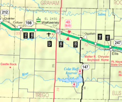 KDOT map of Trego County (legend) | |
| Coordinates: 39°0′31″N 99°41′49″W / 39.00861°N 99.69694°WCoordinates: 39°0′31″N 99°41′49″W / 39.00861°N 99.69694°W | |
| Country | United States |
| State | Kansas |
| County | Trego |
| Area | |
| • Total | 143.9 sq mi (372.7 km2) |
| • Land | 143.8 sq mi (372.5 km2) |
| • Water | 0.1 sq mi (0.2 km2) |
| Elevation | 2,290 ft (698 m) |
| Population (2000) | |
| • Total | 214 |
| • Density | 1.5/sq mi (0.6/km2) |
| Time zone | Central (CST) (UTC-6) |
| • Summer (DST) | CDT (UTC-5) |
| ZIP code | 67656 |
| Area code(s) | 785 |
| FIPS code | 20-52250[1] |
| GNIS feature ID | 0485296[2] |
Ogallah is an unincorporated community in Trego County, Kansas, United States.
History
Ogallah was named for the Oglala Lakota tribe.[3]
The post office was established January 27, 1879.[4]
Climate
The climate in this area is characterized by hot, humid summers and generally mild to cool winters. According to the Köppen Climate Classification system, Ogallah has a humid subtropical climate, abbreviated "Cfa" on climate maps.[5]
See also
References
- ↑ "American FactFinder". United States Census Bureau. Archived from the original on September 11, 2013. Retrieved 2008-01-31.
- ↑ "US Board on Geographic Names". United States Geological Survey. 2007-10-25. Retrieved 2008-01-31.
- ↑ Heim, Michael (2007). Exploring Kansas Highways. p. 30.
- ↑ "Kansas Post Offices, 1828-1961". Kansas Historical Society. Archived from the original on October 9, 2013. Retrieved 27 June 2014.
- ↑ Climate Summary for Ogallah, Kansas
Municipalities and communities of Trego County, Kansas, United States | ||
|---|---|---|
| Cities |  | |
| Unincorporated communities | ||
| Townships |
| |
This article is issued from Wikipedia - version of the 10/23/2016. The text is available under the Creative Commons Attribution/Share Alike but additional terms may apply for the media files.