Orange Grove Mobile Manor, Arizona
| Orange Grove Mobile Manor, Arizona | |
|---|---|
| CDP | |
  Orange Grove Mobile Manor, Arizona Location in the United States | |
| Coordinates: 32°35′54″N 114°39′38″W / 32.59833°N 114.66056°WCoordinates: 32°35′54″N 114°39′38″W / 32.59833°N 114.66056°W | |
| Country | United States |
| State | Arizona |
| County | Yuma |
| Established | 1973[1] |
| Population (2010) | |
| • Total | 594 |
| Time zone | MST (no DST) (UTC-7) |
| ZIP code | 85350 |
| Area code(s) | 928 |
| FIPS code | 04-51465 |
| GNIS feature ID | 2582836 |
Orange Grove Mobile Manor is a census-designated place (CDP) and colonia in Yuma County, Arizona, United States.[2] The population was 555 at the 2010 census. It is part of the Yuma Metropolitan Statistical Area.
Geography
Orange Grove Mobile Manor is located at 32°35′54″N 114°39′38″W / 32.59833°N 114.66056°W (32.598451, -114.660588).[3] It is located to the south of the East Cocopah Indian Reservation.
According to the United States Census Bureau, the CDP has a total area of 0.063 square miles (0.16 km2), all of it land.
References
- ↑ "Adequacy Determinations in the Yuma Basin". Arizona Water Atlas (PDF). 7. p. 438.
- ↑ State of ARIZONA –Department of Housing’s ‐ Designated Colonias As of August 12, 2014 ( excluding Maricopa and Pinal Counties ) (PDF), retrieved 2015-06-17
- ↑ "US Gazetteer files: 2010, 2000, and 1990". United States Census Bureau. 2011-02-12. Retrieved 2011-04-23.
Municipalities and communities of Yuma County, Arizona, United States | ||
|---|---|---|
| Cities | 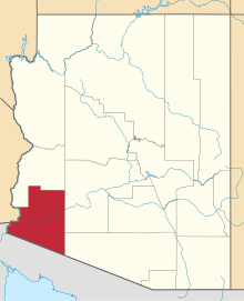 | |
| Town | ||
| CDPs |
| |
| Unincorporated communities | ||
| Indian reservations | ||
| Ghost towns | ||
| Footnotes | ‡This populated place also has portions in an adjacent county or counties | |
This article is issued from Wikipedia - version of the 7/20/2016. The text is available under the Creative Commons Attribution/Share Alike but additional terms may apply for the media files.