Paucarpata District
| Paucarpata Pawqarpata | |
|---|---|
| District | |
|
| |
| Coordinates: 16°24′28.01″S 71°39′47.25″W / 16.4077806°S 71.6631250°WCoordinates: 16°24′28.01″S 71°39′47.25″W / 16.4077806°S 71.6631250°W | |
| Country |
 Peru Peru |
| Region | Arequipa |
| Province | Arequipa |
| Capital | Paucarpata |
| Government | |
| • Mayor | Marcio Soto Rivera |
| Area | |
| • Total | 31.07 km2 (12.00 sq mi) |
| Elevation | 2,405 m (7,890 ft) |
| Population (2005 census) | |
| • Total | 125,255 |
| • Density | 4,000/km2 (10,000/sq mi) |
| Time zone | PET (UTC-5) |
| UBIGEO | 040112 |
| Website | munipaucarpata.gob.pe |
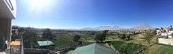
Paucarpata District is one of the twenty-nine districts of the Arequipa Province in Peru.[1] It is noted for its terraced agricultural hills, called andenes in Spanish.
External links
References
- ↑ (Spanish) Municipalidad Distrital de Paucarpata, Municipalidad Distrital de Paucarpata, Retrieved November 16, 2007.
.svg.png)
This article is issued from Wikipedia - version of the 10/31/2015. The text is available under the Creative Commons Attribution/Share Alike but additional terms may apply for the media files.