San Juan de Tarucani District
| San Juan de Tarucani Tarujani | |
|---|---|
| District | |
|
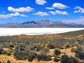
Lake Salinas, Tarucani District | |
| Country |
 Peru Peru |
| Region | Arequipa |
| Province | Arequipa |
| Founded | June 15, 1962 |
| Capital | Tarucani |
| Government | |
| • Mayor | Floro Choque Vilca |
| Area | |
| • Total | 2,264.59 km2 (874.36 sq mi) |
| Elevation | 4,210 m (13,810 ft) |
| Population (2005 census) | |
| • Total | 2,296 |
| • Density | 1.0/km2 (2.6/sq mi) |
| Time zone | PET (UTC-5) |
| UBIGEO | 040119 |
San Juan de Tarucani District (Aymara Tarujani, taruja deer,[1] -ni a suffix, "the one with deer") is one of 29 districts of the province Arequipa in Peru.[2]
Geography
The highest elevation of the district is the Misti volcano. Other mountains are listed below:[3]
- Anta Q'awa
- Anta Saya
- Chachakumani
- Iru Qullu
- Janq'u Apachita
- Jayuni
- Jichu Qullu
- Kunturi
- Kunturini
- Llallawi
- Llallawani
- Misa Misani
- Misa Pilluni
- Ñuñu Muqu
- Pachakutiq
- Parwayuni
- Pikchu Pikchu
- Pilluni
- Pirwani
- Puka Muqu
- Puka Pukayuq
- Pukara
- Puka Saya
- Phichunchäni
- Qillqata
- Qiñwani
- Qiwlla Pununa
- Qullpani
- Qullqirani
- Saywa
- Saywani
- Sinqa
- Sura Wañusqa
- Suri Wasi
- Takuni
- Turini
- Wankarani
- Wanq'uni
- Wayllani
- Wila Muqu
- Wila Wila
- Wilani
- Yuraq Pilluni
- Yuraq Urqu
See also
References
- ↑ Radio San Gabriel, "Instituto Radiofonico de Promoción Aymara" (IRPA) 1993, Republicado por Instituto de las Lenguas y Literaturas Andinas-Amazónicas (ILLLA-A) 2011, Transcripción del Vocabulario de la Lengua Aymara, P. Ludovico Bertonio 1612 (Spanish-Aymara-Aymara-Spanish dictionary)
- ↑ (Spanish) Instituto Nacional de Estadística e Informática. Banco de Información Distrital. Retrieved April 11, 2008.
- ↑ escale.minedu.gob.pe - UGEL map of the General Sánchez Cerro (Moquegua Region)
.svg.png)
Coordinates: 16°10′59″S 71°04′01″W / 16.18306°S 71.06694°W
This article is issued from Wikipedia - version of the 5/27/2016. The text is available under the Creative Commons Attribution/Share Alike but additional terms may apply for the media files.