Pleasant Township, Butler County, Kansas
| Pleasant Township | |
|---|---|
| Township | |
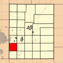 Location in Butler County | |
| Coordinates: 37°36′25″N 097°05′56″W / 37.60694°N 97.09889°WCoordinates: 37°36′25″N 097°05′56″W / 37.60694°N 97.09889°W | |
| Country | United States |
| State | Kansas |
| County | Butler |
| Area | |
| • Total | 36.1 sq mi (93.49 km2) |
| • Land | 36.06 sq mi (93.39 km2) |
| • Water | 0.04 sq mi (0.1 km2) 0.11% |
| Elevation | 1,329 ft (405 m) |
| Population (2000) | |
| • Total | 4,649 |
| • Density | 128.9/sq mi (49.8/km2) |
| GNIS feature ID | 0474233 |
Pleasant Township is a township in Butler County, Kansas, USA. As of the 2000 census, its population was 4,649.
History
Pleasant Township was organized in 1873.[1]
Geography
Pleasant Township covers an area of 36.1 square miles (93 km2) and contains one incorporated settlement, Rose Hill. According to the USGS, it contains two cemeteries: Dunlap and Rose Hill.
Transportation
Pleasant Township contains three airports or landing strips: Flying H Ranch Airport, Graham Airport and Trabue Airport.
Further reading
References
- ↑ Mooney, Vol. P. (1916). History of Butler County Kansas. Standard Publishing Company. p. 180.
External links
Municipalities and communities of Butler County, Kansas, United States | ||
|---|---|---|
| Cities |  | |
| CDP | ||
| Unincorporated communities | ||
| Ghost towns | ||
| Townships | ||
| Footnotes | ‡This populated place also has portions in an adjacent county or counties | |
This article is issued from Wikipedia - version of the 10/31/2016. The text is available under the Creative Commons Attribution/Share Alike but additional terms may apply for the media files.