Predgrad
| Predgrad | |
|---|---|
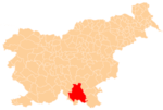
  Predgrad Location in Slovenia | |
| Coordinates: 45°30′16.04″N 15°3′20.32″E / 45.5044556°N 15.0556444°ECoordinates: 45°30′16.04″N 15°3′20.32″E / 45.5044556°N 15.0556444°E | |
| Country |
 Slovenia Slovenia |
| Traditional region | Lower Carniola |
| Statistical region | Southeast Slovenia |
| Municipality | Kočevje |
| Area | |
| • Total | 5.15 km2 (1.99 sq mi) |
| Elevation | 372.1 m (1,220.8 ft) |
| Population (2002) | |
| • Total | 95 |
| [1] | |
Predgrad (pronounced [ˈpɾeːdɡɾat]; German: Vornschloß[2] or Pölland[3]) is a settlement in the Municipality of Kočevje in southern Slovenia. The area is part of the traditional region of Lower Carniola and is now included in the Southeast Slovenia Statistical Region.[4]
The local church is dedicated to Saints Fabian and Sebastian and belongs to the Parish of Stari Trg ob Kolpi. It is a mid-18th-century Baroque building that replaced an earlier church on the site.[5]
The settlement contains the scant ruins of a 13th-century castle that was destroyed in 1809 by Napoleon's forces.[6]
References
- ↑ Statistical Office of the Republic of Slovenia
- ↑ Leksikon občin kraljestev in dežel zastopanih v državnem zboru, vol. 6: Kranjsko. 1906. Vienna: C. Kr. Dvorna in Državna Tiskarna, p. 8.
- ↑ Petrovič, Mihael. 2012. "Ko se vzdigne Puntarija, Kočevski protifrancoski upor leta 1809." In Barbara Šterbenc Svetina (ed.), Zgodovinske dimenzije Ilirskih provinc, pp. 131–151. Ljubljana: Založba ZRC, p. 140.
- ↑ Kočevje municipal site
- ↑ Slovenian Ministry of Culture register of national heritage reference number ešd 2317
- ↑ Slovenian Ministry of Culture register of national heritage reference number ešd 11990
External links
This article is issued from Wikipedia - version of the 3/11/2014. The text is available under the Creative Commons Attribution/Share Alike but additional terms may apply for the media files.