Pyongchon-guyok
| P'yŏngch'ŏn-guyŏk | |
|---|---|
| Korean transcription(s) | |
| • Hangul | 평천구역 |
| • Hanja | 平川區域 |
| • Revised Romanization | Pyeongcheon-guyeok |
| • McCune–Reischauer | P'yŏngch'ŏn-guyŏk |
|
| |
| Country | North Korea |
| Administrative divisions | 11 administrative dong |
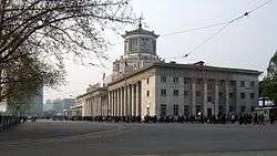
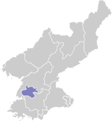
P'yŏngch'ŏn-guyŏk (Pyongchon District) is one of the 19 guyŏk (political districts or wards) of Pyongyang, North Korea. It is bordered by the Taedong River in the South and the Potong River in the north and west, and to the east by Chung-guyok, from which it is separated by the railway. It was established as a guyŏk in October 1960 by the Pyongyang City People's Committee through a mandate of the Central Committee of the Workers' Party of Korea. It is probably best known as the location of the P'yongchon Thermal Power Station, which is the electricity source for Pyongyang's central neighborhoods. It is also the location of the Mansudae Art Studio and School, the Pyongyang Jang Chol Gu University of Commerce, the Pyongyang University of the Printing Industrial Arts and the Korea Okryu Combination Corporation. For international visitors, it is the location of the Pothong Hotel and the Ansan Chodasso Guest House.
Administrative divisions
Pyongchon-guyok is divided into eleven administrative districts known as dong. The largest neighborhoods (Ansan, Puksong, Haeun, Ryukkyo, Pyongchon, and Saemaul) are further divided into two parts for administrative purposes.[1]
| Chosŏn'gŭl | Hancha | |
|---|---|---|
| Ansan-dong | 안산동 | 鞍山洞 |
| Chŏngpy'ŏng-dong | 정평동 | 井平洞 |
| Haeun-dong | 해운동 | 海運洞 |
| Kansŏng-dong | 간성동 | 干城洞 |
| Pongji-dong | 봉지동 | 鳳池洞 |
| Ponghak-dong | 봉학동 | 鳳鶴洞 |
| Pongnam-dong | 봉남동 | 鳳南洞 |
| Puksŏng-dong | 북성동 | 北城洞 |
| P'yŏngch'ŏn-dong | 평천동 | 平川洞 |
| Ryukkyo-dong | 륙교동 | 陸橋洞 |
| Saemaul-dong | 새마을동 | 새마을洞 |
2014 deadly building collapse
A 23-story apartment building collapsed in Pyongchon district around May 18, 2014, potentially killing hundreds of people. The cause of the collapse has been officially declared by North’s official Korean Central News Agency as “irresponsible supervision and control”.[2]
Sources
- ↑ http://nk.joins.com/map/i003.htm
- ↑ http://mashable.com/2014/05/18/north-korea-apology-building-collapse/
Coordinates: 39°00′00″N 125°43′12″E / 39.00000°N 125.72000°E