Raghunathpur subdivision
| Raghunathpur subdivision রঘুনাথপুর মহকুমা | |
|---|---|
| Subdivision | |
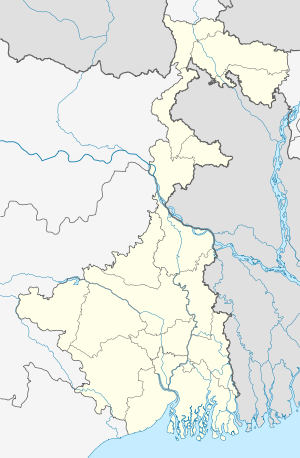  Raghunathpur subdivision   Raghunathpur subdivision Location in West Bengal, India | |
| Coordinates: 23°33′N 86°40′E / 23.55°N 86.67°ECoordinates: 23°33′N 86°40′E / 23.55°N 86.67°E | |
| Country |
 India India |
| State | West Bengal |
| District | Purulia |
| Headquarters | Raghunathpur |
| Area | |
| • Total | 1,559.68 km2 (602.20 sq mi) |
| Population (2011) | |
| • Total | 837,757 |
| • Density | 540/km2 (1,400/sq mi) |
| Languages | |
| • Official | Bengali, English |
| Time zone | IST (UTC+5:30) |
| ISO 3166 code | ISO 3166-2:IN |
| Vehicle registration | WB |
| Website |
wb |
Raghunathpur subdivision is a subdivision of the Purulia district in the state of West Bengal, India.
Subdivisions
Purulia district is divided into the following administrative subdivisions: [1]
| Subdivision | Headquarter | Area km2 | Population (2011) | Rural Population % (2001) | Urban Population % (2001) |
|---|---|---|---|---|---|
| Purulia Sadar West subdivision | Jhalda | 2,327.98 | 1,037,021 | 94.60 | 5.40 |
| Purulia Sadar East subdivision | Purulia | 2,336.20 | 1,055,337 | 87.55 | 12.45 |
| Raghunathpur subdivision | Raghunathpur | 1,559.68 | 83,7757 | 87.37 | 12.63 |
| Purulia district | Purulia | 6,259.00 | 2,930,115 | 89.93 | 10.07 |
Administrative units
Raghunathpur subdivision has 7 police stations, 6 community development blocks, 6 panchayat samitis, 49 gram panchayats, 687 inhabited villages, 1 municipality, 14 census towns. The single municipality is at Raghunathpur. The census towns are: Adra, Kantarangpuri, Lapara, Saltor, Hijuli, Par Beliya, Santaldih Power Project Town, Kanki, Dubra, Chapari, Shankara, Arra, Nabagram and Murulia. The subdivision has its headquarters at Raghunathpur.[2][3]
Area
Raghunathpur subdivision has an area of 1,559.68 km2, population in 2011 of 837,757 and density of population of 537 per km2. 28.59 % 0f the population of the district resides in this subdivision.[4]
Police stations
Police stations in Raghunathpur subdivision have the following features and jurisdiction: [5]
| Police station | Area covered km2 | Inter-state border km | Municipal town | CD Block |
|---|---|---|---|---|
| Raghunathpur | 337 | - | Raghunathpur | Raghunathpur I |
| Kashipur | 801.88 | - | - | Kashipur |
| Adra | 172.92 | - | - | Kashipur |
| Neturia | 203.65 | Damodar River flows along the northern border, Dhanbad district of Jharkhand across the river | - | Neturia |
| Para | 270.59 | Bokaro district of Jharkhand is on the west | - | Para |
| Santaldih | 98.34 | Damodar River flows along the northern border, Sindri in Dhanbad district of Jharkhand across the river | - | Para, Raghunathpur II |
| Santuri | 179.69 | - | - | Santuri |
| Raghunathpur Women | All 7 police station areas of subdivision[6] |
|||
Blocks
Community development blocks in Raghunathpur subdivision are:[4] [7]
| CD Block | Headquarters | Area km2 | Population (2011) | SC % | ST % | Literacy Rate % | Census Towns |
|---|---|---|---|---|---|---|---|
| Kashipur | Kalloli | 451.31 | 200,083 | 28.50 | 24.76 | 71.06 | 3 |
| Neturia | Gobag | 203.65 | 101,427 | 28.86 | 22.30 | 65.14 | 3 |
| Para | Para | 312.59 | 200,621 | 33.27 | 5.15 | 65.62 | 5 |
| Raghunathpur I | Raghunathpur | 201.82 | 117,760 | 35.37 | 10.70 | 67.36 | 1 |
| Raghunathpur II | Cheliyama | 179.69 | 113,790 | 36.44 | 6.42 | 67.29 | 1 |
| Santuri | Muraddi | 368.30 | 78,515 | 25.59 | 31.95 | 64.15 | 1 |
Gram Panchayats
The subdivision contains 49 gram panchayats under 6 community development blocs:[8]
- Para block: Anara, Deoli, Jabarrah–Jhapra–II, Udaypur–Joynagar, Bahara, Dubra, Nadiha Surulia, Bowridih, Jabarrah–Jhapra–I and Para.
- Raghunathpur–I block: Arrah, Bero, Khajura, Sanka, Babugram, Chorpahari and Nutandi.
- Raghunathpur–II block: Barrah, Joradih, Nildih, Cheliama, Mangalda–Mautore and Nutandih.
Dumurkola under Nutandih Panchayat Urban area under this block consists of one census town: Nabagram.

- Neturia block: Bhamuria, Guniara, Raibandh, Sarbari, Digha, Janardandih and Saltore.
- Santuri block: Balitora, Ramchandrapur– Kotaldi, Tarabari, Garsika, Muradi and Santuri.
- Kashipur block: Agardi–Chitra, Gorandih, Manihara, Sonathali, Barrah, Hadalda–Uparrah, Rangamati–Ranjandih, Beko, Kalidaha, Simla–Dhanara, Gagnabad, Kashipur and Sonaijuri.
Electoral constituencies
Lok Sabha (parliamentary) and Vidhan Sabha (state assembly) constituencies in Purulia district were as follows:
| Lok Sabha constituency | Vidhan Sabha constituency | Reservation | CD Block and/or Gram panchayat |
|---|---|---|---|
| Purulia | Balarampur | None | Balarampur CD Block; Chakaltore, Dimdiha, Durku, Garafusra, Lagda and Sonaijuri gram panchayats of Purulia I CD Block; and Chatu Hansa, Hensla and Puara gram panchayats of Arsha CD Block.[9] |
| Baghmundi | None | Jhalda municipality; Jhalda I and Baghmundi CD Blocks; Hetgugui and Sirkabad gram panchayats of Arsha CD Block.[9] | |
| Joypur | None | Joypur and Jhalda II CD Blocks; Arsha, Beldih and Manikary gram panchayats of Arsha CD Block.[9] | |
| Purulia | None | Purulia municipality; Purulia II CD Block; Bhandar Purachipida and Manara gram panchayats of Purulia I CD Block.[9] | |
| Manbazar | ST | Manbazar I and Puncha CD Blocks; Chatumadar, Daldali and Manguria Lalpur gram panchayats of Hura CD Block.[9] | |
| Kashipur | None | Kashipur CD Block; Hura, Jabarrah, Kalabani, Keshargarh, Ladhurka, Lakhanpur and Rakhera Bishpuri gram panchayats of Hura CD Block.[9] | |
| Para | SC | Para and Raghunathpur II CD Blocks.[9] | |
| Bankura | Raghunathpur | SC | Raghunathpur municipality; Raghunathpur I, Neturia and Santuri CD Blocks.[9] |
| Other assembly segments in Bankura district | |||
| Jhargram (ST) | Bandwan | ST | Bandwan, Barabazar and Manbazar II CD Blocks.[9] |
| Other assembly segments in Paschim Medinipur district | |||
References
- ↑ "District Statistical Handbook 2014 Purulia". Table 2.2, 2.4(a). Department of Statistics and Programme Implementation, Government of West Bengal. Retrieved 23 October 2016.
- ↑ "District Statistical Handbook 2014 Purulia". Table 2.1. Department of Statistics and Programme Implementation, Government of West Bengal. Retrieved 29 September 2016.
- ↑ "Directory of District, Sub division, Panchayat Samiti/ Block and Gram Panchayats in West Bengal, March 2008". West Bengal. National Informatics Centre, India. 2008-03-19. Archived from the original on February 25, 2009. Retrieved 29 September 2016.
- 1 2 "District Statistical Handbook 2014 Purlia". Table 2.2. Department of Statistics and Programme Implementation, Government of West Bengal. Retrieved 29 September 2016.
- ↑ "District Statistical Handbook 2014 Purulia". Tables 2.1, 2.2,. Department of Statistics and Programme Implementation, Government of West Bengal. Retrieved 2 October 2016.
- ↑ "রঘুনাথপুরে মহিলা থানা". Issue dated 21 July, 2016 (Bengali). Ananda Bazar Patrika. Retrieved 11 October 2016.
- ↑ "C.D. Block Wise Primary Census Abstract Data(PCA)". 2011 census: West Bengal – District-wise CD Blocks. Registrar General and Census Commissioner, India. Retrieved 29 September 2016.
- ↑ "Directory of District, Subdivision, Panchayat Samiti/ Block and Gram Panchayats in West Bengal". Purulia - Revised in March 2008. Panchayats and Rural Development Department, Government of West Bengal. Retrieved 29 September 2016.
- 1 2 3 4 5 6 7 8 9 "Delimitation Commission Order No. 18 dated 15 February 2006" (PDF). West Bengal. Election Commission of India. Retrieved 10 October 2016.
Cities, towns and locations in Purulia District | |||||||||||
|---|---|---|---|---|---|---|---|---|---|---|---|
| Cities, municipal and census towns |
| ||||||||||
| Locations other than cities and towns |
| ||||||||||
| Neighbourhood | |||||||||||
| Related topics |
| ||||||||||
 West Bengal portal West Bengal portal | |||||||||||

