Sabirabad District
| Sabirabad | |
|---|---|
| Rayon | |
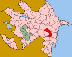 Map of Azerbaijan showing Sabirabad Rayon | |
| Country | Azerbaijan |
| Capital | Sabirabad |
| Area[1] | |
| • Total | 1,470 km2 (570 sq mi) |
| Population (2011)[2][3] | |
| • Total | 155,400 |
| Telephone code | 0143 |
Sabirabad is a rayon of Azerbaijan whose capital, the city of Sabirabad, lies at the junction of the Araz and Kura rivers. The low-lying area is dependent on canals and dams whose damage during 2010 caused waters from Lake Sarisu to flood several of the region's villages.[4][5]
Geography
The rayon is located in the south of Mugan plain.[6] Rayon borders upon Kurdamir Rayon in the north for a distance of 30 km, Shamakhi Rayon in the north-west for a distance of 5 km, Shirvan city in the south for a distance of 24 km, Salyan Rayon in the south-west for a distance of 48 km, Bilasuvar Rayon in the south for a distance of 18 km, Saatly Rayon in the east for a distance of 136 km and Imishli Rayon for a distance of 8 km. Its length from the north to the south is 66 km, and from the east to the west is 24 km. A part of the rayon’s territory is on the right coast of the Kura River, in Shirvan plain.[7]
References
- ↑ "Sabirabad rayonu".
- ↑ "Sabirabad rayonu".
- ↑ "Sabirabad rayonu". The State Statistical Committee of the Republic of Azerbaijan.
- ↑ Flooding in Sabirabad
- ↑ Sarisu waters burst through dam
- ↑ "Sabirabad Rayon". discoverazerbaijan.az.
- ↑ "Sabirabad Rayon". azerbaijan.az.
| Part of the series on |
| Azerbaijan Azərbaycan |
|---|
  |
| Culture |
| History |
| Demographics |
| Geography |
| Administrative divisions |
| Azerbaijan portal |
.svg.png)
Coordinates: 40°0′N 48°36′E / 40.000°N 48.600°E