San Mateo District, Huarochirí
| San Mateo | |
|---|---|
| District | |
|
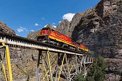
FCCA (Ferrocarril Central Andino) nrs. 1008 and 1009, two GE C30-7, are crossing a steel bridge between Rio Blanco and San Mateo | |
| Country |
 Peru Peru |
| Region | Lima |
| Province | Huarochirí |
| Capital | San Mateo |
| Government | |
| • Mayor | Julio Cesar Del Pozo Campos |
| Area | |
| • Total | 425.6 km2 (164.3 sq mi) |
| Elevation | 3,149 m (10,331 ft) |
| Population (2005 census) | |
| • Total | 4,754 |
| • Density | 11/km2 (29/sq mi) |
| Time zone | PET (UTC-5) |
| UBIGEO | 150722 |
San Mateo District is one of thirty-two districts of the province Huarochirí in Peru.[1]
Geography
The La Viuda and the Paryaqaqa or Waruchiri mountain ranges traverse the district. Some of the highest mountains of the district are listed below:[2]
- Allqa Allqa
- Chinchiqucha
- Chunta
- Kunkus Yantaq
- Llipina
- Mankan
- Ñuñu
- Paqcha
- Pachanqutu
- Paka
- Qullqayuq
- Quri
- Sarayuq
- Shiraq
- Suyruqucha
- Tata Qayqu
- Uqhu
- Uqsha Wallqa
- Utush Mikhunan
- Wamanripa
- Waskha
- Yana Qaqa
- Yana Yana
- Yuraq Anka (Junín-Lima)
- Yuraq Anka (Lima)
- Yawriq
See also
References
- ↑ (Spanish) Instituto Nacional de Estadística e Informática. Banco de Información Distrital. Retrieved April 11, 2008.
- ↑ escale.minedu.gob.pe - UGEL map of the Huarochirí Province (Lima Region)
.svg.png)
Coordinates: 11°45′31″S 76°18′00″W / 11.7586°S 76.3000°W
This article is issued from Wikipedia - version of the 12/30/2015. The text is available under the Creative Commons Attribution/Share Alike but additional terms may apply for the media files.