Saskatchewan Highway 4
| ||||
|---|---|---|---|---|
| Route information | ||||
| Maintained by Saskatchewan Ministry of Highways and Infrastructure | ||||
| Length: | 655 km[1] (407 mi) | |||
| Major junctions | ||||
| South end: |
 US 191, Canada–US border at Monchy US 191, Canada–US border at Monchy | |||
| North end: |
.svg.png) .svg.png) Hwy 224 / Hwy 904 near Grieg Lake Hwy 224 / Hwy 904 near Grieg Lake | |||
| Location | ||||
| Major cities: | Swift Current, North Battleford, Meadow Lake | |||
| Towns: | Rosetown, Biggar, Battleford | |||
| Highway system | ||||
|
Provincial highways in Saskatchewan
| ||||
.svg.png)
Highway 4 is a major highway in the Canadian province of Saskatchewan. It runs from U.S. Route 191 at the United States border near Monchy to Highway 224/Highway 904 at Meadow Lake Provincial Park. Highway 4 is about 655 km (407 mi.) long.
Major communities that Highway 4 passes through are Swift Current, Rosetown, Biggar, Battleford, North Battleford, and Meadow Lake. It also passes The Battlefords Provincial Park.
Intersections from south to north
| Rural municipality | Location | km[1] | mi | Destinations | Notes | ||
|---|---|---|---|---|---|---|---|
| Continues as US 191 south – Malta, Lewistown, Yellowstone National Park | |||||||
| Val Marie No. 17 | Monchy | 0 | 0.0 | Canada – United States border | Hwy 4 begins | ||
| 16 | 9.9 | .svg.png) Hwy 18 west – Bracken, Climax, Robsart Hwy 18 west – Bracken, Climax, Robsart | .svg.png) Hwy 18 concurrency begins Hwy 18 concurrency beginsconcurrency turns northeast | ||||
| Masefield | 18 | 11 | |||||
| 26 | 16 |  Hwy 607 east – Rosefield Hwy 607 east – Rosefield | Concurrency turns north | ||||
| Val Marie | 32 | 20 | Hwy 18 east – Mankota, Fir Mountain, Rockglen | Hwy 18 concurrency ends | |||
| | 34 | 21 | Crosses Frenchman River | ||||
| 48 | 30 | Township Road 50 (West Val Marie Irrigation Project Access Road) | |||||
| Beaver Valley | 55 | 34 | |||||
| Wise Creek No. 77 | 77 | 48 | Hwy 722 west – Shaunavon | ||||
| Cadillac | 87 | 54 | .svg.png) Hwy 13 – Robsart, Shaunavon, Assiniboia, Weyburn Hwy 13 – Robsart, Shaunavon, Assiniboia, Weyburn | ||||
| Lac Pelletier No. 107 | 110 | 68 | Township Road 114 (Studer Road) | ||||
| 113 | 70 | .svg.png) Hwy 43 east – Vanguard, Gravelbourg Hwy 43 east – Vanguard, Gravelbourg | |||||
| 117 | 73 | Township Road 122 (Blumenort Access Road) | |||||
| 119 | 74 | .svg.png) Hwy 343 west – Simmie Hwy 343 west – Simmie | |||||
| Swift Current No. 137 | 123 | 76 | .svg.png) Hwy 379 east – McMahon Hwy 721 west Hwy 379 east – McMahon Hwy 721 west | ||||
| 129 | 80 | Township Road 142 (Rhineland Access Road) | |||||
| 136 | 85 | .svg.png) Hwy 363 east – Hodgeville, Moose Jaw Hwy 363 east – Hodgeville, Moose Jaw | |||||
| City of Swift Current | 143 | 89 | South Railway Street / Airport Road | ||||
| 144 | 89 | Chaplin Street E | |||||
| 146 | 91 |  Hwy 1 (TCH) – Medicine Hat, Calgary, Moose Jaw, Regina Hwy 1 (TCH) – Medicine Hat, Calgary, Moose Jaw, Regina | Grade separated Hwy 4 turns northwest | ||||
| 147 | 91 | Central Avenue N | Hwy 4 branches north | ||||
| Saskatchewan Landing No. 167 | 168 | 104 | Hwy 736 east | ||||
| Stewart Valley | 182 | 113 | Hwy 738 east | Hwy 4 turns west Hwy 738 concurrency begins | |||
| 188 | 117 | Hwy 738 west – Cabri | Hwy 4 turns north Hwy 738 concurrency ends | ||||
| ↑ / ↓ | Saskatchewan Landing Provincial Park | 199 | 124 | Saskatchewan Landing Bridge across Lake Diefenbaker (South Saskatchewan River) | |||
| Lacadena No. 228 | Kyle | 221 | 137 | Range Road 220 | |||
| | 223 | 139 | .svg.png) Hwy 342 – Plato, Beechy, Lucky Lake Hwy 342 – Plato, Beechy, Lucky Lake | ||||
| 239 | 149 | Hwy 647 west – Lacadena | |||||
| Monet No. 257 | 260 | 160 | Hwy 751 east | ||||
| Elrose | 263 | 163 | .svg.png) Hwy 44 west – Eston, Eatonia, Alsask Hwy 44 west – Eston, Eatonia, Alsask | Hwy 44 concurrency begins | |||
| 266 | 165 | Hwy 44 east – Cutbank, Loreburn, Davidson | Hwy 44 concurrency ends | ||||
| 269 | 167 | Hwy 752 west – McMorran | |||||
| St. Andrews No. 287 | 295 | 183 | .svg.png) Hwy 15 east – Outlook, Kenaston, Nokomis Hwy 15 east – Outlook, Kenaston, Nokomis | ||||
| Rosetown | 300 | 190 | .svg.png) Hwy 7 – Alsask, Kindersley, Delisle, Saskatoon Hwy 7 – Alsask, Kindersley, Delisle, Saskatoon | ||||
| Marriott No. 317 | 311 | 193 | .svg.png) Hwy 31 west – Plenty, Kerrobert, Macklin Hwy 31 west – Plenty, Kerrobert, Macklin | ||||
| Marriott | 329 | 204 | Hwy 768 east – Tessier | ||||
| Biggar No. 347 | Biggar | 360 | 220 | .svg.png) Hwy 51 west – Springwater, Kerrobert, Major Hwy 51 west – Springwater, Kerrobert, Major | |||
| 361 | 224 | .svg.png) Hwy 14 west – Unity, Wilkie, Macklin Hwy 14 west – Unity, Wilkie, Macklin | Hwy 4 branches east Hwy 14 concurrency begins | ||||
| 362 | 225 | Hwy 14 east – Asquith, Saskatoon | Hwy 4 branches north Hwy 14 concurrency ends | ||||
| Glenside No. 377 | 387 | 240 | Hwy 784 east – Struan, Dalmeny | Hwy 784 concurrency begins | |||
| Rosemount No. 378 | Cando | 405 | 252 | Hwy 656 south – Landis | |||
| Buffalo No. 409 | 411 | 255 | Hwy 784 west – Wilkie | Hwy 784 concurrency ends | |||
| Battle River No. 438 | | 447 | 278 | Hwy 658 south | |||
| | 448 | 278 | Crosses Battle River | ||||
| Town of Battleford | 448 | 278 | Campbell Innes Way | To Fort Battleford National Historic Site | |||
| 451 | 280 | 22nd Street (Former Hwy 16A) east.svg.png) .svg.png) Hwy 40 west to Hwy 29 south – Wilkie, Cut Knife, Wainwright Hwy 40 west to Hwy 29 south – Wilkie, Cut Knife, Wainwright | Hwy 40 concurrency begins | ||||
| 453 | 281 |   Hwy 16 (TCH) west – Maidstone, Lloydminster, Edmonton Hwy 16 (TCH) west – Maidstone, Lloydminster, Edmonton | Grade separated Hwy 16 (TCH) / Hwy 40 concurrency begins | ||||
| ↑ / ↓ | 453.5 | 281.8 | Battlefords Bridge over North Saskatchewan River | ||||
| City of North Battleford | 454 | 282 | Hwy 16 (TCH) east – Radisson, Langham, Saskatoon Hwy 40 east – Blaine Lake, Shellbrook, Prince Albert Hwy 16B east (Business Loop) Hwy 16B east (Business Loop) | Grade separated Northbound exit, southbound entrance Hwy 16 / Hwy 40 concurrency ends Hwy 16B concurrency begins. | |||
| 454.5 | 282.4 | Territorial Drive S / South Railway Avenue To Hwy 4 north (Bypass Route) – Meadow Lake | North Battleford bypass via Territorial Drive. | ||||
| 455 | 283 | Hwy 16B east (100 Street / Railway Avenue) 11 Avenue | Hwy 4 turns north onto 100 Street Hwy 16B turns southeast onto Railway Avenue Hwy 16B concurrency ends | ||||
| 457 | 284 | Territorial Drive N To Hwy 4 south / Hwy 16 (TCH) / Hwy 40 – Battleford, Lloydminster, Saskatoon | Bypass route | ||||
| North Battleford No. 437 | 461 | 286 | .svg.png) Hwy 378 east – Rabbit Lake, Spiritwood Hwy 378 east – Rabbit Lake, Spiritwood | ||||
| Meota No. 468 | 471 | 293 | Hwy 750 east – Whitkow | ||||
| 474 | 295 | .svg.png) Hwy 26 north – Vawn, Turtleford, St. Walburg Hwy 26 north – Vawn, Turtleford, St. Walburg | |||||
| 480 | 300 | Metinota Access Road | Road accesses the south shore of Jackfish Lake | ||||
| Cochin | 489 | 304 | Hwy 769 east – Rabbit Lake | Hwy 769 concurrency begins | |||
| The Battlefords Provincial Park | 492 | 306 | Access road | ||||
| | 497 | 309 | Hwy 769 west – Aquadeo | Hwy 769 concurrency ends | |||
| Parkdale No. 498 | 512 | 318 | Hwy 794 east – Medstead | Hwy 794 concurrency begins | |||
| 519 | 322 | Hwy 794 west – Turtleford | Hwy 794 concurrency ends | ||||
| Glaslyn | 523 | 325 | .svg.png) Hwy 3 east – Spiritwood, Shell Lake, Shellbrook, Prince Albert Hwy 3 east – Spiritwood, Shell Lake, Shellbrook, Prince Albert | Hwy 3 concurrency begins | |||
| 524 | 326 | Hwy 3 west – Turtleford, St. Walburg, Paradise Hill | Hwy 3 concurrency ends | ||||
| 544 | 338 | Township Road 530 | Access to Helene Lake Provincial Recreation Site Hwy 4 enters Meadow Lake Provincial Forest | ||||
| 555 | 345 | Turtle Lake Road | Access to Turtle Lake Provincial Recreation Site | ||||
| Meadow Lake No. 588 | Halfway House Provincial Recreation Site | 578 | 359 | ||||
| 596 | 370 | Township Road 582 | Hwy 4 exits Meadow Lake Provincial Forest | ||||
| 607 | 377 | .svg.png) Hwy 304 west – Loon Lake Hwy 799 east Hwy 304 west – Loon Lake Hwy 799 east | |||||
| City of Meadow Lake | 613 | 381 | Airport Road | ||||
| 614 | 382 | .svg.png) Hwy 55 east (1 Avenue W) – Green Lake, Shellbrook, Prince Albert Hwy 55 east (1 Avenue W) – Green Lake, Shellbrook, Prince Albert | Hwy 55 concurrency begins Hwy 4 / 55 turns west as it exits Meadow Lake | ||||
| Meadow Lake No. 588 | 624 | 388 | Hwy 55 west – Goodsoil, Pierceland, Cold Lake | Hwy 4 branches north Hwy 55 concurrency ends | |||
| | 640 | 400 | Crosses Beaver River | ||||
| Dorintosh | 647 | 402 | Hwy 779 west – Peerless | ||||
| Meadow Lake Provincial Park | 654.5 | 406.7 | Crosses Waterhen River | ||||
| 655 | 407 | Hwy 224 west – Greig Lake Hwy 904 north | Hwy 4 ends | ||||
| Continues as Hwy 904 north | |||||||
1.000 mi = 1.609 km; 1.000 km = 0.621 mi
| |||||||
Gallery
-
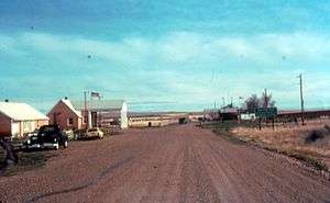
Val Marie border crossing U.S. into Canada
-
Highway 4 south of Swift Current, northbound
Highway 4S
Several maps, such as MapArt's mapbook of Saskatchewan Cities and Towns shows a Highway 4S spur heading east from the intersection of Highway 4 in Swift Current to the city's airport, following Airport Road. The roadway is not designated Highway 4S on the Saskatchewan Highway's 2011 Official Highway Map.
References
- 1 2 Corporation, Microsoft (2009). "Bing Maps". Microsoft Corporation. Retrieved 2009-07-14.