Southorpe Roughs
| Site of Special Scientific Interest | |
 | |
| Area of Search | Cambridgeshire |
|---|---|
| Grid reference | TF 073 031 [1] |
| Interest | Biological |
| Area | 9.8 hectares[1] |
| Notification | 1986[1] |
| Location map | Magic Map |
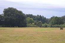
Southorpe Roughs is a 9.8 hectare Site of Special Scientific Interest west of Southorpe in Cambridgeshire.[1][2]
This is a disused quarry which has grassland on Jurassic limestone. The main grasses are tor-grass and sheep's fescue, and there are the nationally rare plants spotted cat's ear and pasque flower.[3]
The site is private land with no public access.
References
- 1 2 3 4 "Designated Sites View: Southorpe Roughs". Sites of Special Scientific Interest. Natural England. Retrieved 30 August 2016.
- ↑ "Map of Southorpe Roughs". Sites of Special Scientific Interest. Natural England. Retrieved 30 August 2016.
- ↑ "Southorpe Roughs citation" (PDF). Sites of Special Scientific Interest. Natural England. Retrieved 30 August 2016.
 |
Wikimedia Commons has media related to Southorpe Roughs. |
Coordinates: 52°36′54″N 0°25′01″W / 52.615°N 0.417°W
This article is issued from Wikipedia - version of the 11/28/2016. The text is available under the Creative Commons Attribution/Share Alike but additional terms may apply for the media files.