Tábua
| Tábua | |||
|---|---|---|---|
| Municipality | |||
| |||
 | |||
| Coordinates: 40°21′37″N 8°01′45″W / 40.36028°N 8.02917°WCoordinates: 40°21′37″N 8°01′45″W / 40.36028°N 8.02917°W | |||
| Country |
 Portugal Portugal | ||
| Region | Centro | ||
| Subregion | Pinhal Interior Norte | ||
| Intermunic. comm. | Região de Coimbra | ||
| District | Coimbra | ||
| Parishes | 11 | ||
| Area | |||
| • Total | 199.79 km2 (77.14 sq mi) | ||
| Population (2011) | |||
| • Total | 12,071 | ||
| • Density | 60/km2 (160/sq mi) | ||
| Time zone | WET/WEST (UTC+0/+1) | ||
| Website |
www | ||
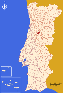
Tábua (Portuguese pronunciation: [ˈtaβuɐ]) is a municipality of the Coimbra District, in Portugal. It contains the town of Tábua. The population in 2011 was 12,071,[1] in an area of 199.79 km².[2]
Parishes
Administratively, the municipality is divided into 11 civil parishes (freguesias):[3]
- Ázere e Covelo
- Candosa
- Carapinha
- Covas e Vila Nova de Oliveirinha
- Espariz e Sinde
- Midões
- Mouronho
- Pinheiro de Coja e Meda de Mouros
- Póvoa de Midões
- São João da Boa Vista
- Tábua
References
- ↑ Instituto Nacional de Estatística
- ↑ Direção-Geral do Território
- ↑ Diário da República. "Law nr. 11-A/2013, page 552 117" (pdf) (in Portuguese). Retrieved 31 July 2014.
This article is issued from Wikipedia - version of the 7/9/2016. The text is available under the Creative Commons Attribution/Share Alike but additional terms may apply for the media files.