Washington Township, Putnam County, Indiana
| Washington Township | |
|---|---|
| Township | |
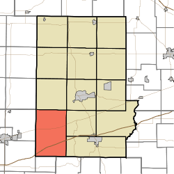 | |
| Coordinates: 39°32′35″N 86°57′19″W / 39.54306°N 86.95528°WCoordinates: 39°32′35″N 86°57′19″W / 39.54306°N 86.95528°W | |
| Country | United States |
| State | Indiana |
| County | Putnam |
| Government | |
| • Type | Indiana township |
| Area | |
| • Total | 53.28 sq mi (138.0 km2) |
| • Land | 52.97 sq mi (137.2 km2) |
| • Water | 0.31 sq mi (0.8 km2) |
| Elevation[1] | 738 ft (225 m) |
| Population (2010) | |
| • Total | 2,493 |
| • Density | 47.1/sq mi (18.2/km2) |
| FIPS code | 18-80972[2] |
| GNIS feature ID | 454015 |
Washington Township is one of thirteen townships in Putnam County, Indiana. As of the 2010 census, its population was 2,493 and it contained 1,086 housing units.[3]
History
The Putnam County Bridge No. 159 and Lycurgus Stoner House are listed on the National Register of Historic Places.[4]
Geography
According to the 2010 census, the township has a total area of 53.28 square miles (138.0 km2), of which 52.97 square miles (137.2 km2) (or 99.42%) is land and 0.31 square miles (0.80 km2) (or 0.58%) is water.[3]
References
- ↑ "US Board on Geographic Names". United States Geological Survey. 2007-10-25. Retrieved 2008-01-31.
- ↑ "American FactFinder". United States Census Bureau. Retrieved 2008-01-31.
- 1 2 "Population, Housing Units, Area, and Density: 2010 - County -- County Subdivision and Place -- 2010 Census Summary File 1". United States Census. Retrieved 2013-05-10.
- ↑ National Park Service (2010-07-09). "National Register Information System". National Register of Historic Places. National Park Service.
External links
Municipalities and communities of Putnam County, Indiana, United States | ||
|---|---|---|
| City | 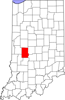 | |
| Towns | ||
| Townships | ||
| CDPs | ||
| Other unincorporated communities |
| |
| Footnotes | ‡This populated place also has portions in an adjacent county or counties | |
This article is issued from Wikipedia - version of the 6/19/2016. The text is available under the Creative Commons Attribution/Share Alike but additional terms may apply for the media files.